Dry Acheron 31 January 2024

Leader Mentor Understudy Tail Ender
Standards Jen C Chris S Sally Kate
Alternates Norma Gavin Ali Marie-Therese

Distance 13.4km; duration 3hrs 45min; vertical ascent 180m

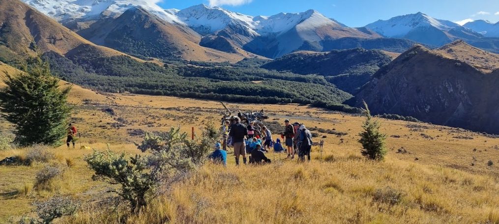
As the sun painted the skies a pure cloudless blue, 41 eager trampers from Bishopdale Tramping Club gathered, our  destination the iconic Dry Acheron Track, on a day that promised a symphony of landscapes, challenges and the camaraderie that defines our tramping community.

There was a sense of anticipation, the rustle of grass – and pine cones – beneath our boots marking the beginning of a day filled with adventure. The track offers unobstructed views of the surrounding landscape including distant views of the Southern Alps and meanders through flat grasslands, along stream verges and rocky dry stream beds. It presented us with 24 stream crossings before lunch (!)  – a quintessential Kiwi tramping experience.

The history of the Dry Acheron Track includes the early days of European settlement of New Zealand. Originally a stock route, it evolved into a well-traversed pathway connecting the plains to the high country. Its significance in the region’s history was palpable as we ventured along the well-trodden track, tracing the footsteps of those who once relied on this very route.

The moderately graded natural stream verge provided variation, a chance for trampers to appreciate the subtleties of the environment. As we delved deeper into the rocky dry stream beds, the sun rose higher, the day got hotter and the terrain became more challenging, demanding nimbleness and agility. Each step was a dance with the landscape, a delicate negotiation with the rocks and pebbles beneath our feet. The trampers, ranging from seasoned hikers to those new to high country trails, embraced the challenge with enthusiasm – and a few naughty words!

The temperature reached 24 degrees Celsius. Happily a gentle breeze on the return walk added to our overall enjoyment. Departing from Lake Coleridge Road, the temperature in the bus had reached 30 degrees! The Dry Acheron Track had not only tested our collective mettle but had also opened the gateway to the many hikes we can look forward to in this region this year.                           Txt by Brent McC with the assistance of ChatGPT

Hilltop-Cooptown 24 January 24


  Leader Mentor Understudy Tail Ender
Standards Chris S Jan Br Kay Ailsa
Alternates Ali Norma Linley Tessa

Distance 13km (approx); duration 4hrs 30min; vertical ascent 504m

It was a lovely fresh 10 degree morning with an almost autumnal feel when 47 trampers including visitors Judy S and Andrea (Linley’s daughter) boarded the bus for Little River with first time BTC driver Geoff.  Shirley and Dave shared the joy of their new grandson Quinn with a generous chocolate shout. Update from last week’s new bidet owner  – it’s not yet installed so no christening to report.

In one of the paddocks stood the statue of a large white cattle beast. One of our trampers when driving to Akaroa on Monday had witnessed a large white beast upside down, legs in the air surrounded by several men. She found it quite upsetting to think it must have died and was waiting to be lowered into a trench. Now standing proudly on a rock. On our return trip a sign revealed more, Silverstream Charolais and Herefords is a stud operation. This set us googling – Silverstream Evolution – probably the best bull ever bred – 50 daughters in the herd – semen to die for, x-factor quality.

 After a slow journey with many traffic cones and a traffic light 32 Standards set off at 1020 from the Hilltop Tavern car park. Through a paddock of friendly cows and over a stile soon had us heading uphill in the Montgomery Reserve which found us posing for the group photo at the massive forked tōtara tree, supposedly 2000 years old. Tōtara trees are slow growing and can live for 1000 years so this one has obviously missed the memo. The forest is stunning with tōtara and mataī and the contrasting orange papery bark of the fuchsia. The monolithic rock steps – slippery in the wet, have not got any closer together so give a whole new meaning to stretching the legs. The track climbs sharply through regenerating bush and a gap in the bluffs to reach open space on the top of the hill and morning tea in the sunshine at 1120.

The next section involves walking through tussocks and bracken some almost waist high and climbing several hills while viewing the sparkling waters of Pigeon Bay to the north. The hillsides are littered with the carcasses of silver stumps and haunting skeleton trees. It is easy to be transported back in time to imagine the peninsula when two thirds was covered by dense podocarp forest of tōtara and mataī and filled with birdsong. The forests were ruthlessly cleared by both fires and felling to clear the land for dairying and provide timber to build Christchurch. In 40 years the forest and native birds had disappeared. Trees came down and cheese production went up. In 1857 there were 18 dairies on the peninsula.

The perfect lunch spot was reached at 1305 with plenty of stumps and logs for resting on with magnificent regenerating bush at our backs and the blue of the bays below. From different positions on the track you can view Pigeon Bay, Lake Ellesmere, Lake Forsyth and Akaroa. The Alternates who had commenced their hike at the junction of Pigeon Bay and Pettigrews Road and hiked uphill though Whatarangi and Sinclair Reserves were looking very contented at the end of their lunch break as we arrived. No shortage of space here and a log for everyone.

Chris our leader led us ably on our descent through farmland on very slippery grasses with several boggy areas and a timely warning to watch out for the tree nettle ongaonga. It has a nasty sting which doesn’t fade quickly. There were numerous slides, a leg caught in the wire of a fence when climbing through (suggest a yoga retreat to improve flexibility) and an unfortunate unplanned swim at the last river crossing but no serious injuries. We reached the bus along the road in Cooptown at 1520, five minutes after the Alternates.

It had been perfect tramping weather with sunshine and cloud but no rain, birdsong in the bush, cow pats ++++, haunting forest, regenerating bush and bay views to die for. It was after 1700 when the bus arrived back in Bishopdale all feeling in good spirits after a great tramp.

Txt by Kate W

Rakaia Gorge 17 January 24

Leader Mentor Understudy Tail Ender
Standards Peter M Graham W Brent Kay and Kate
Alternates Eric Norma Gary G Min

Distance 10.3km; duration 4hrs 20min; vertical ascent 414m

For our first walk of the year we had 45 trampers including one visitor, Judy S. Our driver was Viktor. We welcomed the return of Selwyn and Pip following surgeries and injury. On a day like Wednesday was, this is a perfect first walk for the Club. Gentle ups and downs, sun and dappled shade and views of the  glacial turquoise of Canterbury’s biggest braided river, the Rakaia. The river was formerly known as Ō Rakaia meaning the place where people were ranged in rank, referring to the practice of strong men standing in line to break the force of the water when crossing. For Ngai Tūāhuriri of Kaiapoi it was a mahinga kai/food gathering place. Apparently at the river’s mouth up to 1,000 earth oven sites used for cooking moa have been recorded.

Mention has to be made of the wrought iron bridge – one of the country’s oldest. Constructed between 1880 and 1882 by Oamaru’s W H Barnes, the bridge features a timber deck and handrail atop its wrought iron plate girder and truss. The truss is unconventional in having no bottom chord and its ties fan out from the gorge’s edge carrying the load forces to the bridge’s anchors. It’s a handsome bridge.

It was a walk filled with catching up with summer goings-on, news of growing families and adventures had and planned, house moves and bathroom renovations. We do look forward to finding out who got first use of Brent’s new bidet! Punctuated by bellbird song and walking amid knee-high grass with Tussock Butterflies floating beside us talk turned to frequency of cat grooming, finding indestructible toys for dachshunds – and turtles.

Alternates and Standards all lunched beside the river and on our return walk some of us followed a side track to look at the old coal mine site. When all were back on the main track  our two groups had merged and we walked out together though a little crawling was required by some with a fallen tree over the track. One of our number was all over the fallen tree issue and once on the bus had reported it to Snap Send Solve by 1526 hrs. By 1600 hrs she had received five replies ultimately advising that the issue of the fallen tree is currently with ECan. Hopefully ECan will deal with the tree promptly. The track had been busy with mid-week walkers – domestic and international.

In response to our tramp leader’s enquiry the Hororata Café advised that they were short-staffed and closing at three so Viktor drove us home without stopping. A thoroughly enjoyable first walk for 2024.         Text by Jen C

Sources

Te Maire Tau, Anake Goodall, David Palmer & Rakiihia Tau. Te Whakatau Kaupapa: Ngāi Tahu Resource Management Strategy for the Canterbury Region, Aoraki Press, 1990

Aidan J. Challis, Ka Pakihi Whakatekateka O Waitaha: The Archaeology of Canterbury in Māori Times, Department of Conservation, December 1995

G M Jones; ‘Rakaia Gorge Bridge – The truss that isn’t‘ (PDF 1MB), Proceedings of the 1st Australasian Engineering Heritage Conference, 1994.