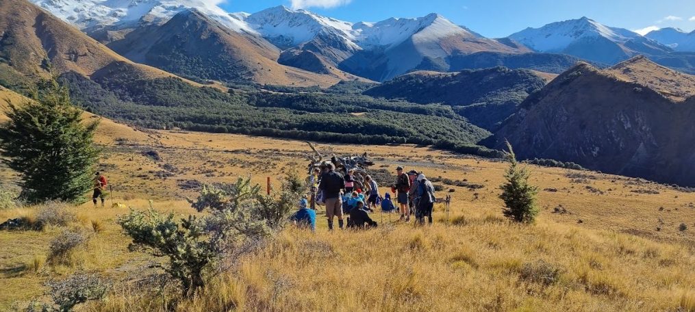
Flagpole Hill 10 April 2024

Leader Mentor Understudy Tail Ender
Standards Dave B Chris Dave F Veronica
Alternates Ali Linley Maureen C Min

Stats for Alternates & Standards:

Distance 15.3 & 17.3km             Vertical ascent 312 & 781m                     Walking time 3.75 & 4 hours

Daylight saving made for a welcome brighter beginning to the day. Weather warnings were about, so there was some toing and froing with the phone before setting out from home. Visitors Bruce H and Glen T made our total 39 trampers – almost a full bus. Our driver was David.

On arrival Flagpole Hill looks straightforward – a steady climb up farm tracks surrounded by golden tussock. However, the Standards’ approach is along the Selwyn River/Waikirikiri (translation gravelly water) followed by ascending forestry roads which gain in gradient and go on and on. Some relief was got from sightings of a deer and a rabbit.

As we gained height conversation turned to How much further? Which was met with questionably helpful variations of We’re nearly there, It’s not much of a mountain, Lunch is just around the corner, I can see the light at the top of the hill! Eventually lunch really was around the corner, in a sheltered spot, with a view of peaks and darkening clouds that made the climb well worthwhile.

After lunch we bore the brunt of the nor’wester, but the rain held off and the view from Flagpole Hill topped everything. The walk down is straightforward and the Standards happily were back at the bus shortly after the Alternates.

The Alternates were ably led by Ali who managed to strike a good balance of reining everyone in and maintaining a decent pace (one of our number was seen to be running up a hill mightily impressing those who were chugging their way up).

An investigation was made of the adit of a mine reputed in the Club to be for silver. Subsequent searching located in UC research repository a document from 1928 recording that several drives (for copper) were put in in the upper reaches of the Selwyn with disappointing results, https://ir.canterbury.ac.nz/bitstreams/31414363-6a5b-49a4-9df4-b5d736d2e56d/download

Along the way was a variety of bird life, including Paradise shelducks/Pūtakitaki, and some other ducks in the distance which on closer inspection turned out to be sheep… The beautiful tan coloured cattle (unmistakable) in the paddocks were admired. Both for their potential as handbags or boots, plus the steaks.  Noone knew the breed.

A good walk on all counts, in excellent company.

Text by Marie-Therese and Jen with thanks to the team who provided statistics

Bellbird Loop 3 April 2024

Leader Mentor Understudy Tail Ender
Standards Glenys Judy R Brent Sally
Alternates Norma Kay L Kay L Marie-Therese

Distance 9km                                        Vertical ascent 480m                              Duration 4 hours

With a forecast high of 220C for Christchurch City, our cheerful trampers boarded the bus at Bishopdale with expectations of an excellent day ahead.

Our driver Stuart had to face at least three extra challenges before we could start walking. Firstly, a very short extra wait at PMH for a late “caught in traffic” arrival; next a careful and tactful wait at the intersection with Dyers Pass Rd for a “we almost left you behind, sorry” member after the Takahe toilet stop; and third was our arrival at the John Jameson Lookout Carpark to find the gate still closed and locked! He remained delightfully calm throughout these interruptions.

When the 38 trampers emerged from the bus, we grabbed jackets, hats and gloves as protection from the unexpectedly strong cold wind and fog funnelling up from the Governors Bay side over us. Brrrr….

Now, with all the negative vibes left behind, we all hoped that guests John and Mark and visitor Bruce would enjoy their hike with us. We set off across the road to the Sign of the Bellbird on the first circle of our planned figure of eight tramping loop. The Standards followed the Orongomai Trail in Kennedy’s Reserve down into the valley while the Alternate group started on that trail too before taking the Fantail Track which gave them a shorter loop. The highlight for both groups, other than the beautiful forest, was the flitting and chirping presence of numerous pīwakawaka (fantails) all the way around. They seemed delighted with our company and the fact that we were stirring up the track surface for them. There was always at least one alongside us all the way – magic! Apparently pīwakawaka live very short lives – no more than 3 years – but they reproduce 2 or more times per year.

By the time the Standards arrived back at the Bellbird Shelter for morning tea, the Alternate group had long gone to continue on the second section of the figure of eight. Fortunately the wind, though still cool, had calmed a bit so that the walk down the Cass Ridge Track to join O’Farrells Track was surprisingly pleasant.

O’Farrells Track sidles along above Governors Bay with shelter from healthy bush and some stunning views. Clouds had gradually cleared away so that the harbour looked very picturesque. Constant birdsong accompanied us along this section too and we felt appreciation for the many volunteer hours of trapping and track maintenance regularly carried out in this area. Once we joined the Bush Road Track with its steady climb upwards to thoroughly warm us up, there was less chatter until we reached somewhere to perch in sunshine for lunch.

We joined the Crater Rim Walkway above the Summit Road to return to our waiting bus by 1.30pm – after a relatively short but very good day out hiking. Thank you to the planning team for mapping out this new hike for us.

During the day we had seen the result of major fire damage to many sections of the land during the Port Hills fires of mid-February 2024. We also noted that the sculpture that has been a stunning new feature of the John Jameson Lookout was missing from the top of its substantial plinth. These have recently introduced a rather sad aspect to Christchurch’s beautiful Port Hills. We look forward to its recovery.

Text by Janne

Coal Pit Spur 27 March 2024

Leader Mentor Understudy Tail Ender
Standards Warren Chris S Jen C Judy R
Alternates Tessa Norma Pip L Maureen C

Distance: 12.6km                   Elevation gain: 772m (inc Helicopter Hill)             Total time: 4hrs 20mins

With the promise of clear(ish) skies and mild temperatures, 39 trampers including visitors Nicky C and first-timer Glen T, eagerly embarked on a day promising adventure, camaraderie, and stunning landscapes. Birthday chocolates and lollies were passed around the bus. Thank you Bernice. And thank you to our driver Garth.

The Standards, comprised of 23 intrepid adventurers, charted a course up the Luge Track, aiming to reach the ridge before descending to Flock Hill Station. Luge Track proved to be a rewarding ascent, with sweeping views of the surrounding mountains reminding us of the breath-taking beauty of the Canterbury high country.

The allure of Helicopter Hill proved irresistible to many of the Standards who opted to add an extra 30 minutes (in total) to their journey to conquer this imposing peak. A few felt some trepidation on seeing to the north the scree face descent of the upcoming Camp Saddle tramp. The river crossing on the return to the bus was described by a couple of people as “very refreshing”. (Others may have described it as cold and wet!)

Meanwhile, the Alternates consisting of 16 trampers, embarked on a shorter route starting from the drop off at the Broken River access road and looping around Coal Pit Spur before returning to the bus. The Alternates were treated to stunning views, native forest, and fabulous birdsong. In the course of their walk, trampers picked up rubbish left by prior careless visitors. Items such as broken glass, lubricant tubes, coffee cups and McDonald’s wrappers were brought out to maintain the integrity of what should be a pristine area.

It was another day of free flowing conversation as people shared tales of past adventures, current activities and challenges. As they made their way back to Christchurch, the trampers reflected on the day’s adventures with fondness, grateful for the opportunity to connect with nature and with one another. Text By Brent M

Okuti Valley 20 March 2024

Leader Mentor Understudy Tail Ender
Standards Dave R Wendy Lynne R Jan M
Alternates Michele Norma Kay Pip

Distance: 9.5km & 15km                        Elevation gain: 720m                      Total time: 4hrs 30mins

What to do when there is a fire ban at the scheduled tramp in North Canterbury, or a landowner won’t allow access across their farmlands? Heading for an out and back walk to a well-known watering hole seemed to be a practical response to such dilemmas. Of course, there were also downfalls to this solution. More accurately several hours of walking up hill and down dale from Okuti Valley Scenic Reserve to Hilltop and back, rather than attaining the summit of French Peak itself.

44 walkers were greeted in Chinese, Korean, Māori and English by Jen our VP, substituting for our president who was potentially up to her knees in mud on Rakiura Track. Jen welcomed visitors Nicky C and Stella P, introduced our driver Tony, and extended congratulations to the Riddler grandparents on their new family member. A good effort all round and chocolates gratefully received.

A brisk breeze rippled the surface of Lake Forsyth/Wairewa, a portent of the cool easterly wind that accompanied us for most of this clear autumn day. 23 Standards and 21 Alternates set off steadily upwards through the Okuti Valley Scenic Reserve, a small but delightful area of lowland native forest with tree ferns, hanging vines, flitting fantails, vocal bird song.

The Standards were soon out of sight, though after our welcome morning tea stop and once on the open farmland above the road, they were visible in the distance. Plodding ever upward towards the saddle, slowing down noticeably at a boggy section where keeping boots mud free was well-nigh impossible. Perhaps making it even boggier for those behind.

Alternates followed along, ably led by Michele on her last tramp before returning to USA, escaping the New Zealand winter. It seemed we were like the sheep that were moving uphill along the narrow tracks, all going in the one direction. Magnificent views of Banks Peninsula hilltops and valleys surrounded us all day.

Standards eventually reached the Hilltop Tavern, but alas any plans for a midday beverage were scuppered as the pub was closed, undergoing restoration. Lunch was thus partaken in the nearby paddock, a minor disappointment, one could imagine.

Meantime Alternates lunched beside a rocky outcrop near the saddle, with views to Kaitorete Spit and well sheltered from the wind. It always seems shorter on the downhill return walk, nonetheless Alternates made good time. 50 minutes of whiling away time in the sun beside the bus is not a bad thing at the end of a 9.5km walk. Standards, having done a 15km walk, reported that it was also pleasant on their return, aided by a tail wind, albeit the track having a distinct lack of coverage for those requiring a toilet stop. So it was said.

Another great outing with BTC members. Thanks to everyone for the encouragement, laughter and good company.                         Text by Marie-Therese

PMH – Bowenvale 13 March 2024

Leader Mentor Understudy Tail Ender
Standards Graham W Jan Br Brent Frank
Alternates Ray Daphne Ali Eric

Distance:12.5km                               Elevation gain: 600m                        Total time: 4hrs 15mins

An eager group of trampers alighted from the bus at PMH where they were joined by a smaller group including visitor Nicky C waiting in the carpark.

At 9.15am the groups set off,  Alternates following the Standards as they steadily made their way up the short track to Lady Polson Lane. Surrounded by a variety of fruit and nut trees,  we passed by the Cracroft Caverns. The Caverns had been secretly constructed during World War 2 when, in the event of an attack, they were to be used as South Island operational headquarters. Following the war the Caverns remained largely forgotten until their chance discovery in 1987. More recently they provided a stable environment for the University of Canterbury’s ring laser laboratory measuring variations in the earth’s rotation.  The Caverns have been closed to the public since the Canterbury earthquakes.

On Lady Polson Lane one sharp-eyed member of the group observed a gorgeous specimen of purple autumn crocus. (The deceased hedgehog in the adjoining gutter didn’t receive such positive attention). From Hackthorne Road, we made our way up to Cracroft Reserve and the Sign of the Takahē continuing uphill to Victoria Park, where we stopped at the top for morning tea.

Back on the track we paused to observe the awful devastation caused by the recent bush fires on the Port Hills. On Latter’s Spur Track we climbed through native bush to a rocky spur with spectacular views across Lyttelton Harbour. From there we continued along to Mitchell’s Track (which is part of the Crater Rim Walkway) to Scott’s Reserve where our leader Ray found a perfect lunch spot providing a great view of the valley and shelter from the wind.

After a convivial lunch, the eight intrepid Alternates descended the Bowenvale Valley Track. En route we were entertained by the sight of two mobs of sheep being mustered by clever, fearless and obedient dogs under the  command of their respective owners.

Forty five minutes later the Alternates group reached the end of their descent at Bowenvale Avenue where the Standards were waiting by the bus. To complete a very enjoyable day, we adjourned to the Brickworks for refreshments before heading back to the bus.

Thanks to Frank for providing us with chocolates celebrating his birthday and to Marie-Therese for hers in celebration of the arrival of her latest grand daughter. Thank you to Stuart our bus driver for the day.

Text by Margaret C

Boundary Hill – 6 March 2024

Leader Mentor Understudy Tail Ender
Standards Chris S Alan H Jen Marg E
Alternates Ray Gavin M Ali Moira

Stats: Standards & Alternates

Distance: 11 & 7.6km                                    Elevation gain: 418m                Time: 4hrs 48mins & 4 hrs

After picking up the group at Yaldhurst, 46 trampers set off in the bus with driver Stuart for the drop off point along the Lyndon Coleridge Road. Although sunny when we arrived, the wind was a bit chilly so extra layers were put on before the 24 standards and 22 alternates set off along a four-wheel drive farm track.

Both groups initially followed the same track, until shortly after scrambling over a washout in a gully the standards branched off to the right taking a longer route to Boundary Hill, while the alternates carried on further up the track to their morning tea stop. By this stage the cool wind had dropped away and extra layers were being discarded.

The farm track gave way to a boggy landscape scattered with prickly matagouri and Spaniard grass. Matagouri is a New Zealand native and has complete protection on public conservation land and some protection on private land. The spines of the plant were used by Māori for tattooing when there were no better tools available.

With no real track it was slow going, especially for those at the front forging their way through the matagouri and tussock and on uneven ground warning those following with occasional shouts of “Hole”! Back on firmer ground at the top of the ridge, the standards could be seen across the gully in the distance.

Reaching the base of Boundary Hill, some elected to have lunch at the bottom, while 13 of the group trekked up the narrow path to the top. The view from the top of the hill taking in Lake Coleridge and the Rakaia River with a smattering of snow on the distant mountains was well worth the climb, and there was still plenty of seating in the sun for the standards when they arrived a short time later.

After lunch, with some of the group thinking how fortunate they were to be avoiding the steep drop-off on the route the standards were taking, the alternates made a unanimous decision to follow the fence line down, rather than retrace their steps on the narrow path, which would have been slippery due to loose stones.

Arriving at the bottom with shredded legs, except for those with long pants on, the two groups reformed for the tramp back to the bus, taking the route the standards had taken on the way in. Earlier discussions about orange markers and pre-cut matagouri meant the return trip was easier, and the fault line, marked by a stony ridge lacking vegetation, was reached without incident. There was time to take some photos before the group moved on.

After one last climb and descent, it was encouraging to see the bus in the distance. The route back was reasonably straightforward, apart from having to cross a small stream, where some got to show off their long-jump skills. Helping hands on the other side meant everyone got across safely.

With a quick change of footwear, it was back on the bus for the drive further up the road to pick up the waiting standards.
Although there were a couple of sticking points, it was an enjoyable tramp with ‘a bit of everything’.

Text by Sally

Pony Point to Barnett Park – 28 February 2024

Leader Mentor Understudy Tail Ender
Standards Chris S Wendy A Chris H Brent
Alternates Ali Jan B Michele S Stuart C

Distance: 13km                                                         Elevation gain: 580m                                  Time: 4hrs 30 mins

Today’s walk was a day with mist and wind making for a cooler start as we set out, 44 walkers in total. Four members had been collected at Barnett Park, our scheduled end destination. Our driver Viktor deposited 27 Standards at Pony Point and the further 17 Alternates a little closer towards Lyttelton, whereupon Shanks’ pony became the order of the day. Throughout the day there was a good deal of rearranging attire to suit the conditions.

Alternates made way for Standards as they, too, arrived at Three Piece Suite Reserve for the morning tea stop. Alternates closely followed by Standards, all then carefully followed the mapped route to the start of the track proper. Frequent cries of “Car” sounded out as we headed upward through the narrow Lyttelton streets.

While climbing the many steep steps of Major Hornbrook Track, a descending quartet enquired who we might be. The quick, straight-faced response was that we were passengers from the cruise ship Queen Victoria currently in port, dominating the Lyttelton terminal. There was surprised admiration from the walkers until one more reliable member admitted that we were actually from BTC.

Still further up the hill one member observed that it was a little easier walking along a graded uphill track than ascending steps. That’s because there is a cadence to the walking, was a considered viewpoint. A cautionary sign warned us to move quickly through the potential rock fall area. Picking up the pace was easier said than done, more of a keeping on going and getting to the top, good rhythm or otherwise. Both groups eventually achieved the Summit Road whereupon walkers draped themselves beside flax bushes, leeside of wind and mist, and enjoyed their lunch.

Standards soon disappeared from view into the mist, with speculation by Alternates as to where they might be. Mystifyingly the Standards loomed out of the mist behind the Alternates, having been on a loop track to the gun emplacements. Though with lack of visibility they, too, could have told the Alternates another tall tale. It was pretty much downhill at that point – via the Eastenders Track to Barnett Park and sunshine.

Everyone was back at the waiting bus around 1430 hrs. With the early finish we were then able to conclude the day with refreshments at The Valley Inn Tavern before the drive back across the city.

Listed diary volunteer Jen who had been unable to tramp due to a bee sting incident suggested the inclusion of a random pony fact. So for what it’s worth, and because the question was once posed… How high can a Shetland Pony jump? According to Google these ponies can jump about a meter.

In summary, another good day of exercise, encouragement, good leadership, laughter and conversation, albeit with little view from the vicinity of Summit Road.

Text by Marie-Therese


Hogs Back Track – 21 February 2024

Leader Mentor Understudy Tail Ender
Standards Dave R Sally Brent Glenys
Alternates Les G Ali Eric S Les H & Gary

Distance: 15km                                     Elevation gain: 500m                     Time walking: 4hrs approx

Another early notification of tramping route change away from the Port Hills saw 42 walkers being transported westward by our driver James, to the Craigieburn Forest Park. This saw the writer abandoning a diligently sourced screed of frivolous pony data. Said writer also announced a new filly in her family, and celebrated the safe delivery of granddaughter Melanie with a sharing of goody bag.

Hogs Back 1032 m. This small peak is reminiscent of the shape of a lenticular cloud, otherwise known as a “hogs-back” for its distinctive form, which often indicates a powerful system moving in. Combined with strengthening winds, this often means a storm will approach in the next 6-24 hours. The cloud type is familiar to Cantabrians with the Foehn effect, the nor’westerly airstream that flows from the Tasman Sea over the Southern Alps. Cirrus or “mare’s tales” are another first sign of an approaching front.

For anyone who has spare time, there is a Cloud Appreciation Society   https://cloudappreciationsociety.org though from listening to the varied activities of our members, there seems little idle time on the horizon. Today there was an absence of cloud in the cerulean blue sky, a stunning day, though the early approach of autumn was noted.

After setting out from Castle Hill Village the 14 Alternates didn’t quite make it to Picnic Rock, a 15th member of the group having been escorted back to the bus in an early retreat, after becoming unwell. With the two groups there was competition for the limited shade at The Lightening Tree as we all enjoyed our morning tea stop. Both groups navigated the switchbacks through undulating beech forest, over open tussock, across bridges and through streams. Bird song elevated the setting along the way.

The 27 Standards continued on to the top of Hogs Back, lunched at the top, but soon returned back down to the shade as “it was very hot”. However this was not before viewing in the distance a lone paraglider, plus a mirage, indicative of the still conditions and hot day. Meantime the Alternates quietly lunching in the shade were surprised by the sound of people returning along the track. Had the Standards raced down and snuck up on them? Not at all, it was a group from the Over Forties TC, also enjoying their walk, away from the city.

Both Alternates and Standards chose to walk back along the longer but less steep track, the vote of one dissenter being overruled in favour of the majority. The lone walker conceded and plodded cheerfully on. Alternates arrived back at the bus about 10 minutes ahead of the Standards, approx. 12.5 km for Alternates, 15.3 km for Standards.

There’s much to be grateful for on such days – good company, conversation, leadership roles well undertaken, along with all the benefits of exercising in the great outdoors.

Text by Marie-Therese

PMH – Governor’s Bay 14 February 2024

Leader Mentor Understudy Tail Ender
Standards Dave R Alan H Cath L Veronica
Alternates Graham W Lynne R Jan Br Tessa

We received an early warning that our scheduled Glenafric tramp was cancelled due to the danger of fire and we soon learned it was to be replaced by this new tramp. The Standards disembarked at PMH and did a wander uphill (mostly) before looping around and entering the Canterbury Adventure Park (CAP). Meanwhile the Alternates were dropped at the start of the CAP track that leads through the park and eventually to Worsleys Road. The temperature forecast was for 29 degrees so all 35 trampers were keen to get cracking before the sun reached its zenith.

The Standards, looking for a convenience stop at morning tea, found that most of the many toilets at the Park’s HQ were locked, requiring some to explore other options, including the café’s loos one of which required passing the delicious food and wine on display. Resisting temptation, we reconvened and were soon setting off up the track. At this stage, we were all feeling a lot of love (it was February 14, remember) for those who had designed the path with the many switchbacks enabling us to master the increase in altitude without much difficulty. Unfortunately, as the zigzags disappeared and the steeper grunts presented themselves, falling out of love came a lot easier than the steady uphill climb which was now our reality. A big thank you to our fellow trampers who patiently assisted those for whom the going was getting tough!

The Standards had lunch at the top of the track beneath a large shady tree with a pleasant breeze to cool us as well. At the end of the day, when the two groups met up at our destination, some were astonished to learn that the Alternates had pressed on to the Sign of the Kiwi for lunch. Here, a former member met up with her husband. How lovely we thought – a romantic assignation on this special day! But no, there had been no expectation of actually seeing each other, and Margaret and Eric ate their lunch at separate tables. The Alternates then walked around Coronation Hill before reaching the start of the Governors Bay Downhill Track.

Having been assured at lunch that “It is all downhill from here” some of us did wonder later if this remark had been a rather bleak comment about the person’s own future, or perhaps directed at those lying semi-comatose around him, rather than an accurate description of the topography. However, reaching the same track as the Alternates ahead of us, we found that it was indeed mostly a downhill walk with some very hot open sections interspersed with beautiful cool bush and cheering birdsong to lighten the mood.

Stopping for the obligatory photograph at the Reuter Park Memorial to Horst and Christa, there was a lot of interest in the pair. In the course of googling – the local Reuters gifted 23 ha of land above Governors Bay to the City Council in 1994 – I can tell you it’s best to avoid Reutter Park in Michigan USA where there have been three shootings in the last year!

And now for those who deal in stats: Standards walked approx. 14.1 km (sounds very specific for an approximation); elevation gain 745 metres (surely that should be a 9 at the start of that number); and took 4.75 hours. Alternates covered 12km approx.; climbed 540 metres and were out and about for 4.16 hours (4hrs 10 mins for those who can’t find the calculator). And Gary was able to tell us that at the turnaround at Worsleys Road we were 1501ft (457.5m) above sea level. In a nutshell all that is really important is that the Alternates beat the Standards to the bar at Ōtoromiro Hotel by 35 minutes! Well done! And thank you for leaving plenty of cool refreshments for the second team home.

Starting the homeward journey, it was evident that not too many had been able to postpone gratification, i.e. save Linley’s birthday chocolates until later. Whenever they were consumed, we enjoyed the treat. Thank you, Linley. As we bused down Dyers Pass Road (thank you to our driver Viktor for navigating the road and hill-parking) it was very sobering and worrying for us all to find that having our expected tramp cancelled due to the risk of fire, we were now looking at what appeared to be a large fire in much the same area as we had just been walking. We are thinking of all those families who have had to be evacuated in the face of this rapidly moving threat and hope that it will be contained and extinguished before reaching the disastrous proportions of the Port Hills fire seven years ago.

Finally, a huge thank you to the Programme Committee for this new walk, and to the leaders, mentors and tailenders of both groups who kept us on the straight and narrow.

Text by Jan Bw


Mt Alford 7 February 2024

Leader Mentor Understudy Tail Ender
Standards Steve Bw Jan Br Jen C Brent
Alternates Ray Norma Jan Bw Ali

Distance 9.72km     Vertical ascent 724m       Duration 5 hours approx

An earlier 8am start was set for this tramp.

Our driver Viktor picked up 38 trampers from Bishopdale and Yaldhurst and we set off down the Main South Road.  At our comfort stop at Rakaia, we had to compete with a bus load of tourists for the excellent facilities.  Some typical Kiwi/tourist interactions quickly established  their nationalities, itinerary and of course how much they were enjoying Aotearoa/NZ.

Thompsons Track is reliably boring with an unrelenting view of dairy farms along the way.  It was a relief to get to the Alford Reserve car park and get underway soon after 10am.  Our intrepid leader Steve, led off across the paddock and into the Alford Scenic Reserve, despite the fact that he’d never done the tramp before.  He reckoned that as he had three mentors and four advisors, he’d be ok!

This DOC managed forest has suffered considerable wind throw and a chain saw would have been useful as we weaved and climbed over trees across the track.  The forest is unusually wet due to poor drainage and the shape of the surrounding hills which catch moist weather from most directions.  In earlier times it grew giant podocarps which unfortunately were logged and burned so that today it is largely black and mountain beech trees.  There are some other native trees starting to be observed: marble leaf (Carpodetus serratus), lancewood (Pseudopanax), horopito/ pepper tree (Pseudowintera axillaris), red matipo or māpou (Myrsine australis). Due to seriously low rainfall recently, the track was unusually dry, with the usual wet and swampy parts reduced to dried mud.  It didn’t take long for the sonorous calls of the korimako to be heard.  After a solid climb up through the bush, we took morning tea at a break in the bush, looking out over the plains.

As we emerged from the bush we were met by a descending, athletic young woman who told us she was celebrating her first day in eight weeks without her children, who were back at school.  She looked so fresh and chirpy, belying the fact that she had just summitted Mt Alford.  She certainly made us feel our age!

After the landmark picnic table, where the Alternates traditionally have lunch, our Leader struck up the hill along the fence line, in preference to the track which zig zags up the hill to mitigate the steepness.  His many advisors must have been asleep!  The direct fence line route was extraordinarily steep and slippery, requiring us to pull ourselves up using the fence.  Eventually we met up with the route markers and we followed them the rest of the way to the summit. The steep route took us through sub alpine scrub, consisting of predominantly Dracophyllum and snow tussock but with the usual smattering of spaniard (Aciphylla colensoi) known as taramea in te reo Māori.  As we got near the summit we observed the Alternates taking lunch on a lower peak.

The summit of Mt Alford (1171m) is an extensive flat area, dominated by a huge cairn.   We had glorious 360 degree views, in overcast conditions but no wind, for our lunch on the top. To the west the skies were clear and blue but to the east, low cloud invaded during our lunch so we commenced the descent in cloud.   This cleared somewhat as we reduced our altitude.

Back at the bus, the bloodied legs of several people told the tale of the damage imposed by spaniard.  Other than that, and the fact that the Alternates had been back for an hour, it was generally agreed that it had been a most enjoyable tramp and definitely one worth remaining on the Club’s programme.                                                        Text by Selwyn