Craigieburn Forest Park 5 June 2024

Group Leader Mentor Tailender
Standards Brent Lynne R Chris H
Alternates Les Linley  Kiwan

Distance 14km                          Ascent   612m                            Duration 4 hours

On a clear sky morning with a promising forecast for sunshine, 36 trampers with bus driver Tony departed Yaldhurst promptly at 8.45am. As we headed west, I think some trampers from last week were relishing the thought of an upright day with no prolonged bending or spade work. President Jen welcomed everyone and advised Bruce H was now a member of BTC. A pair of woman’s size 12 zip-off Kathmandu walking pants were going free for anyone interested. Not sure if they have been snapped up (enquire next week).

At 10.20am 26 Standards were dropped at Mistletoe Flat at Broken River and set off at a steady pace up the ski field access road where the ground was sparkling with the heavy frost. Hats and gloves were the order of the day for most. At 10.40am, when a sunny grassy clearing appeared, it was time for morning tea. The tailender had competently carried out all aspects of his role but had violated the dress code. He was advised the high vis vest was to be worn over his head not draped over his backpack. He obediently obliged.

A little tomtit joined us and later in the day we spotted another one making it a “two tomtit day”. The male’s distinctive song is “ti-oly-oly-joly-ho” that lasts for 2-3 seconds. The men might like to practise that.

Shortly after morning tea we turned right on to the Luge Track to continue uphill through the stunning mountain beech covered in lichens and mosses with the lyrical notes of the bellbirds for company. At 11.45am we reached the Lyndon Saddle where the Craigieburn Valley Track and the Luge Track meet.

The “buzz” on my section of the track was a lively discussion about bees following a recent news item about a North Canterbury beekeeper who had to destroy his whole livelihood due to AFB (American foulbrood). It’s a bacterial disease that destroys the honey bee colonies and once infected they never recover. His argument was he had spores only that were below the level to cause an infection. No risks can be taken with all the bee boxes and equipment having to be set on fire otherwise he could face a criminal prosecution. In NZ it is illegal to use antibiotics to control.

I was advised that, to detect it, you need to poke the brood by placing a small poker such as a match (handy hint, don’t light the match first) into the brood and when you withdraw it you will find a chocolate-like strand which, if not already, will shortly be foul smelling. Enough about foul diseases.

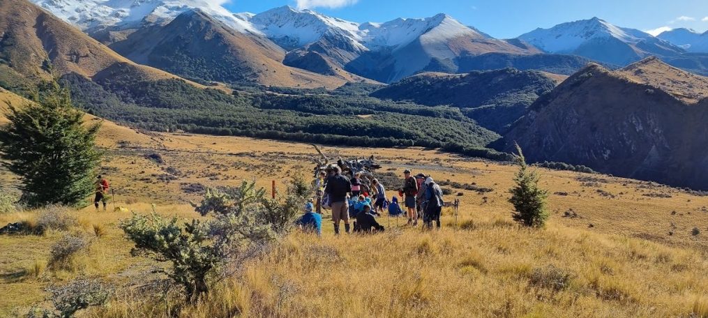
From the saddle we hiked on the Valley Track which provided more birdsong and stunning mountain and forest vistas as we crossed several steep scree slopes. When we came out of the forest to the tussocks and sub alpine plants in bright sunshine, we stopped for lunch perched above the track as it was now 12.45pm.  A mountain biker was spotted approaching and as we had nowhere to move to he carried his bike over 26 trampers and their lunch. Next, those who saw him bike across the shingle scree had their hearts in their mouths. Another lunchtime excitement was to be joined by a kea which walked across the track before disappearing in to the forest.

After lunch a short walk through the tussocks takes you to the Craigieburn Valley Ski Field where you observe a very steep rope tow (the steepest in NZ) before the well-maintained lodges which provide accommodation for the skiers. This ski field is for intermediate and advanced skiers only, and has 3 fast rope tows, the first installed in 1949. Broken River Ski Field next door was first skied in 1951 and was voted the best club field in NZ  in 2023 providing off-piste skiing and snowboarding at its best. It has 5 rope tows and often the longest ski season in Australasia.

I have included this ski field info for the “birthday boy” who shouted last week boasting he now qualified for free skiing. If he is feeling adventurous nothing better than trying off-piste snowboarding.

There was plenty of time for chatter on the long downhill back to the bus on the ski field access road where we arrived at 2.40pm 5 minutes after the Alternates.

The Alternates had been dropped off at the Craigieburn Valley carpark where they walked up the access road before turning left on to the Valley Track. They had an uneventful hike with nobody coming to grief crossing the scree slopes. They enjoyed their lunch in the ski field carpark.

Tony had us back at Bishopdale by 4.30pm after a wonderful day in the Craigieburn Forest that never disappoints.

Text by Kate


Tree Planting – Barnett Park 29 May 2024

Leader Mentor Tail Ender
One Group  Alan Bev

It was a cool grey morning when the bus departed Bishopdale for our annual tree planting exercise.  After stopping to pick up more trampers at Princess Margaret Hospital carpark we numbered 39 including one guest (Neville) and one visitor (Bruce). Our President greeted everyone on the microphone with “Good Mornings” that covered every nationality on the bus including Te Reo. We were all very impressed with her skills. Chocolates were circulated – one bag from Dave R who was excited as his birthday allowed him to qualify for free skiing (even more excited than when he received his Gold Card) and one from Pip as it was one year almost to the day since she broke her fibia on the same excursion (the walk part not the tree planting!). I’m pleased to say she has fully recovered.

We arrived at the Summit Road Carpark driven expertly by our wonderful Viktor, and crossing the road walked up a short distance to the Urumau Reserve, the same area we planted last year.  We were met by Park Ranger Fiona and her two assistants from Council who had prepared the ground by scraping out the top vegetation. They had placed a variety of native plants in the cleared spots for us to plant.  Shovels and gloves were handed out and, as we were short of a few spades, some of us worked in pairs, one digging and one assembling the plant cage and stakes to place around the plant.  We started planting about 10am after watching a “correct way to plant your tree” demonstration by Fiona.  The ground was quite hard due to the very dry summer. It was important to mulch correctly around the plant once one managed to break the ground and plant the tree. Much talking and laughter made short work of the 420 trees planted.  Viktor, our driver, also assisted with the planting. Such enthusiasm! Brent nearly took himself out with a bamboo stake (that was the worst part of the planting – trying to get those bamboo stakes in the hard ground without snapping them – Fiona made it look so easy!) We had a short break for morning tea at 11am and finished up at mid-day. A very satisfying couple of hours.

We then walked back down to the carpark where the bus was parked and had our lunch under the pine trees at the top of Richmond Hill. The wind had come up from the south and it was becoming bitterly cold. We were keen to get walking and set off at about 1pm to walk down the Eastenders Track to the Barnett Cave Loop Walk Track. Squally showers and wind battered us at the top but once down to the track leading to the cave it was considerably calmer.  We climbed up 70 wooden steps to enter the cave to find four people sitting there enjoying the views.  The sound is so amplified in the cave that as we walked up it sounded like there were a lot more people than four in there so it must have been very noisy when we all arrived. There were great views down the valley.  Some of our trampers had never been into the cave before so found it interesting.  We walked down the steps and followed the loop trail back to the bus. We found the left side of the loop going down a little greasy in places on some of the rocks and it was a narrower path.  There were a few slips as our feet skated out from beneath us but we all arrived back at the bus in one piece apart from a couple of bruises!  The light rain was enough to cause the greasy rocks.

As we arrived at the bus at 2.15pm there was plenty of time for a stop-off for a drink on the way home.  We dropped into the Brickworks, Viktor skillfully managing to park the bus appropriately. The most dangerous part of the day was crossing the road.  We departed at 3.20pm for home, dropping off some of our trampers at PMH on the way.  A great day out, the planting timed perfectly before the change in the weather.

Text by Judy R


Leader, Mentor and Tailender Responsibilities

On a tramp, all groups shall have a designated leader and tailender. The leader, tailender and President or substitute may consult prior to the tramp, therefore the two front seats of the bus may be reserved for their use and they shall give any details for the day over the PA.

Leaders

    • The leader shall be responsible for:
    • the route to be followed
    • the time and place of any refreshment stops, including lunch
    • setting a suitable pace, ensuring the Tailender is able to catch up quickly if a gap develops
    • consulting with the President, or substitute, if a serious problem develops
    • the leader can advise against a member’s participation in a tramp or part of a tramp. Noting any member returning to the bus must be accompanied by at least one other person
    • carrying the second first aid kit and beacon when only one group
    • nominating a person to be responsible for leaving gates as found.

Mentor

    • The Mentor shall be responsible for:
    • having thorough knowledge of the details of the route to be followed
    • giving guidance in all aspects of the tramp to the leader
    • observing closely the route that is being followed
    • making notes of significant markers/waypoints and any updates/additions required for clarity of the track on the Leader’s Guide
    • providing this information to the responsible Planning Committee member

Tailender

    • The tailender shall be responsible for:
    • knowing how many are in the group
    • notifying the leader of any problems within the group
    • ensuring an appropriate person is identified to look after any tramper(s) needing help.  A list of those with first aid training, willing to help, is available in the First Aid kit
    • carrying a Club First Aid Kit or assigning to another person if unable to carry themselves (who will walk with the tailender).

Updated 30/05/2024

Greta Valley 15 May 2024

Leader Mentor Understudy Tail Ender
Standards Alan Selwyn Kate Marg E
Alternates Ali Norma Linley Eric

Distance: 14 km          Time: 4 hours          Elevation gain: 504m

Leaving Bishopdale in high spirits with the promise of a pleasant farm walk in North Canterbury ahead, we were all delighted to see Viktor as he has been on other driving duties for the last few months. Jen welcomed us in a number of languages and may have to add Viktor’s first language to these. We made good time up the main road north and soon pulled over opposite the Greta Valley pub. We quickly divided into our two groups – 27 walking with the Standards and a small group of 11 with the Alternates. The first pleasant surprise was that the tricky fence did not have to be negotiated as this year the gate was unlocked. We all poured through gratefully, especially those of us who had torn our shorts the week before and really didn’t want to have to consign a second pair to the bin had the barbed wire etc been misjudged. The wide track winding steadily uphill provided good conditions underfoot and the weather was perfect – warm sunshine and not a breath of wind. We all enjoyed the rest provided by the morning tea stop and the opportunity to take in the surrounding countryside.

A fellow tramper was able to inform us that the valley was named by the first two landowners in the 1850s, after the river Greta in Yorkshire. There was no sighting of a river but the light on the western foothills was certainly noteworthy.

We walked on uphill for the most part until the trusty landmark – the freezer – was duly spotted. As this signals the gate where a left turn is required up the final hill before lunch, it is important that it is not missed.   As far as I’m aware, this is the first year that anyone has thought to investigate the contents of said appliance. Curiosity got the better of some of the Alternates. On opening the lid, the True Crime afficionados were secretly disappointed to not find dismembered body parts – not even dog tucker. What was found was large empty plastic containers. Speculation regarding their purpose kept everyone distracted from the last uphill grunt before lunch.

The lunch stop provided wonderful wide vistas of the foothills, ranges behind and farmland below. The Standards were soon joined by our other group and as there was plenty of space for all 38 of us, there seemed no urgency to move on. However, the call to “saddle up” was heard soon enough and off we went for the last section of the walk, including the last climb of the day. What was remarkable were the very dry conditions and the strange state of the ground we were walking on. Some were heard to describe it as “lunar-like” and none was inclined to disagree, even if we were short on first-hand experience of the moon’s surface!

The final long downhill section of the track has to be taken cautiously as a slip or a slide seemed inevitable at some point. Negotiating the final water hazard we were greeted by a couple of toy dogs as we made our way to the bus. An unfamiliar sight awaited us – Viktor with his feet up having an afternoon nap. We were sorry to have to disturb him, he looked so relaxed. In due course the Alternates arrived and we finished our day out as we had started – enjoying the sunny day, the passing scenery, being able to relax and enjoy conversing with our fellow club members – or those of us still awake who were able to enjoy these things.

Text by Jan Bw

Camp Saddle 8 May 2024

Leader Mentor Understudy Tail Ender
Standards Selwyn Chris S


Lynn B


Judy R
Alternates Ray


Wendy


Pip


Tessa


Standards: Distance: 13.4 km    Ascent: 853 m    Time: 4 hr 50 min

Alternates: Distance: 9.93 km    Ascent: 485 m    Time: 3 hr 47 min

Leaving promptly at 8:30 am, our bus driver Callum took us via the Springfield toilet block where we were luckily the first to arrive of 3 buses. The Standards leader then led some of the group into a bus full of people in long robes and Burkas. Being observant, he realised that he didn’t know any of them, and luckily got off in time to find the right bus.

At 10:20 a.m. the driver dropped us at the start of this adventure, where I anticipated walking through beautiful bush filled with bellbirds, glimpsing amazing views, scrambling over stones etc. The Standards had a kilometre-long descent on scree to look forward to – a highlight for some.

We grouped into 19 Alternates and 18 Standards, and the able Alternates leader Ray took us onto Mistletoe Track, a gradual 4-wheel drive ascent through mountain beeches, flanked by a very steep drop to a stream.  At 11 a.m. Ray found a welcome sunny spot to stop for morning tea. The weather was crisp, perfectly cloudless and windless.

Then the track continued, as hoped, into mountain beech canopies with only moss and beech saplings on the forest floor. Bellbirds did indeed sing all the way. Higher up there were mainly older beech saplings, and a strange, beautiful white fern in the waterways. Perhaps its autumn colouring?

At 12:15 some Alternates lunched at the Lyndon Saddle near Helicopter Hill, while others did the 20-minute walk up the hill (1256m above sea level), rewarded by spectacular 360° views over lunch. But one tramper’s nice vegetarian lunch was nearly spoiled by blood dripping from fingers cut by a sharp stone on the path. The return was steep, down the rocky top of Helicopter Hill to join the rest of the Alternates and proceed down to Sidle Track, accomplished with decorum and without incident.

Meanwhile the Standards had apparently just thrown themselves down the scree slope. Some went feet first but found that ice below the scree made hard unyielding patches. The new secretary chose to go sideways down the scree and scraped all down the left side. The leader of the Standards had sat down and slid until his shorts got a big hole.  Another did it all – tore her shorts, scraped both shins and hugged a tree as well on the way down.

They eventually reached the bus where the Alternates had been for 1 1/2 hours, admiring the blue sky, rippling steam and nearby Helicopter Hill and snowy ridges.

Text by Daphne

Glenafric 24 April 2024

Leader Mentor Understudy Tail Ender
Standards Jan Br Selwyn Graham W Jen C
Alternates Peter M Ali Ali Judy S

Distance 14.25km                                  Ascent 640m                                          Duration 5hrs

When the 36 of us, including third-time visitor Glenn, made it off the bus for our much anticipated Glenafric tramp, the dry conditions made it obvious why there had been concerns about the fire risk.

Glenafric is a 770 hectare mixed farm in Waipara, run by James and Maria Hoban and family. It is not to be confused with Glen Affric, the 4,000 hectare luxury estate in the Scottish Highlands and owned by Pippa Middleton’s in-laws. There are similarities; our local Glenafric has a little B&B cottage. You can stay at the Scottish Glen Affric too, however the accommodation there costs several thousands of pounds a night.

It was impressive to see how far we had climbed by the time we got to our morning tea stop; we could see a plane buzzing way below us, just over the sea. The choice of where to sit was summed up by one as “prickle or poo?”.

Crossing the Dovetail Stream many times wasn’t a problem as the water level was extremely low.  We were fascinated by the sandstone and limestone features we passed.

The 23 Standards enjoyed a spectacular lunch spot on a cliff top overlooking the sea. We were just settling in, enjoying the fabulous warm sunshine, when we were rudely interrupted by the Alternates who wanted this prime spot all to themselves.

So off again, walking along narrow sheep tracks through tall dry grass, heading down to the rocky beach below. Part of the attraction of the beach is finding an interesting fossil or an unusual stone, however our beach experience was limited to a few metres, as the tide was too high.

As we were forging along in the direction of the Glenafric homestead we were hailed from a hill above us by the Alternates. They had an incident with a farm gate which had decided to have a bit of fun with their group, and it needed a hand (24 hands in fact) to get back to its rightful position of vertical.

Striding through the undergrowth and the occasional boggy patch, thoughts of the Glenafric/Glen Affric connection resurfaced. Admittedly, you don’t get a stunning sea view from the highland Glen Affric, but it is very close to Loch Ness. The wildlife we saw could easily have been found in Scotland: cattle, sheep, bees in their hives, a falcon, some geese, and purportedly, even a stag. Other than a little matagouri and a few cabbage trees, the vegetation of grass and pine trees might have been found in that other Glen Affric, with thistles a plenty (good thing no one was wearing a kilt!).

Both groups made it up that last terrible hill back to the high terrace where our driver Stuart was waiting with the bus.  So how many gates had we encountered, opened and dutifully closed? Maybe 12? How many fences, with electric or barbed wire at the top had we gingerly climbed over or through? Also about 12? And how many hills had we climbed … let’s not even go there. It had been such a glorious autumn day that no complaints were to be heard.

Text by Shirls

Monument-Mt Herbert-Diamond Harbour 17 April 2024

Leader Mentor Understudy Tail Ender
Standards Alan Chris S Brent Kate
Alternates Ali Norma Kay Moira

Distance 14.5 km                                                Ascent 552m                                        Duration 4 hrs 30 mins

Mt Herbert (Te Ahu Pātiki) is 920m, the highest point on Banks Peninsula. Starting from Port Levy Saddle as we did, it is a 552m climb. The name in Māori means shaped like a flounder. The Chatham Islanders’ tradition is that their ancestors came from here.

Schools had autumn holidays so our ride was quite quick, via the Halswell Library pick-up. We welcomed two visitors – Mark and Linley’s daughter Andrea.

10:10 am: Andrew our driver delivered us (15  Alternates, 25 Standards) to Monument Track (north). Monument is a huge conical landmark on Port Levy Saddle, popular with mountaineers. Although tramping kilometres uphill, we remained just below Monument, seeming to advance nowhere.

10:30: Morning tea – still just below Monument. All enjoyed the views of bush-clad valleys dropping steeply to Port Levy.

Finally passing Monument we followed the track gradually upwards in the prevailing white mist, with only glimmers of Lyttelton Harbour ahead. What the waters below lacked in colour, they made up for in shimmering light. Cool winds caused us to layer up and put on gloves.

12:23: Reached Mt Herbert peak, lunch time.

Our able leader suggested that being early, we could go back for another loop around…but that conversation went nowhere. The Standards were already there in a spot sheltered from the chilling breeze. They were only half way through their lunch so the Alternates, despite our leader’s suggestion, just piled in and squeezed among the prime spots.

Helen, with the Standards, had spotted a falcon perched on a rock, before it flew off.

The walk downhill from the peak to Diamond Harbour was uneventful except for passing through herds of beautiful black cows and their half-grown calves. They looked at us benignly but curiously, as if we are most peculiar creatures. Indeed we always appear somehow strung together in a line, never stopping to munch a swag of choice grass no matter how green, nor drink from the occasional pools no matter how soft the muddy edges.

The mist cleared at last and on the long way down we were treated to sunshine and spectacular views of Lyttelton Harbour and beyond.

3:30: Joined the Standards at the bus after a hard but very rewarding tramp.

Text by Daphne


Flagpole Hill 10 April 2024

Leader Mentor Understudy Tail Ender
Standards Dave B Chris Dave F Veronica
Alternates Ali Linley Maureen C Min

Stats for Alternates & Standards:

Distance 15.3 & 17.3km             Vertical ascent 312 & 781m                     Walking time 3.75 & 4 hours

Daylight saving made for a welcome brighter beginning to the day. Weather warnings were about, so there was some toing and froing with the phone before setting out from home. Visitors Bruce H and Glen T made our total 39 trampers – almost a full bus. Our driver was David.

On arrival Flagpole Hill looks straightforward – a steady climb up farm tracks surrounded by golden tussock. However, the Standards’ approach is along the Selwyn River/Waikirikiri (translation gravelly water) followed by ascending forestry roads which gain in gradient and go on and on. Some relief was got from sightings of a deer and a rabbit.

As we gained height conversation turned to How much further? Which was met with questionably helpful variations of We’re nearly there, It’s not much of a mountain, Lunch is just around the corner, I can see the light at the top of the hill! Eventually lunch really was around the corner, in a sheltered spot, with a view of peaks and darkening clouds that made the climb well worthwhile.

After lunch we bore the brunt of the nor’wester, but the rain held off and the view from Flagpole Hill topped everything. The walk down is straightforward and the Standards happily were back at the bus shortly after the Alternates.

The Alternates were ably led by Ali who managed to strike a good balance of reining everyone in and maintaining a decent pace (one of our number was seen to be running up a hill mightily impressing those who were chugging their way up).

An investigation was made of the adit of a mine reputed in the Club to be for silver. Subsequent searching located in UC research repository a document from 1928 recording that several drives (for copper) were put in in the upper reaches of the Selwyn with disappointing results, https://ir.canterbury.ac.nz/bitstreams/31414363-6a5b-49a4-9df4-b5d736d2e56d/download

Along the way was a variety of bird life, including Paradise shelducks/Pūtakitaki, and some other ducks in the distance which on closer inspection turned out to be sheep… The beautiful tan coloured cattle (unmistakable) in the paddocks were admired. Both for their potential as handbags or boots, plus the steaks.  Noone knew the breed.

A good walk on all counts, in excellent company.

Text by Marie-Therese and Jen with thanks to the team who provided statistics

Bellbird Loop 3 April 2024

Leader Mentor Understudy Tail Ender
Standards Glenys Judy R Brent Sally
Alternates Norma Kay L Kay L Marie-Therese

Distance 9km                                        Vertical ascent 480m                              Duration 4 hours

With a forecast high of 220C for Christchurch City, our cheerful trampers boarded the bus at Bishopdale with expectations of an excellent day ahead.

Our driver Stuart had to face at least three extra challenges before we could start walking. Firstly, a very short extra wait at PMH for a late “caught in traffic” arrival; next a careful and tactful wait at the intersection with Dyers Pass Rd for a “we almost left you behind, sorry” member after the Takahe toilet stop; and third was our arrival at the John Jameson Lookout Carpark to find the gate still closed and locked! He remained delightfully calm throughout these interruptions.

When the 38 trampers emerged from the bus, we grabbed jackets, hats and gloves as protection from the unexpectedly strong cold wind and fog funnelling up from the Governors Bay side over us. Brrrr….

Now, with all the negative vibes left behind, we all hoped that guests John and Mark and visitor Bruce would enjoy their hike with us. We set off across the road to the Sign of the Bellbird on the first circle of our planned figure of eight tramping loop. The Standards followed the Orongomai Trail in Kennedy’s Reserve down into the valley while the Alternate group started on that trail too before taking the Fantail Track which gave them a shorter loop. The highlight for both groups, other than the beautiful forest, was the flitting and chirping presence of numerous pīwakawaka (fantails) all the way around. They seemed delighted with our company and the fact that we were stirring up the track surface for them. There was always at least one alongside us all the way – magic! Apparently pīwakawaka live very short lives – no more than 3 years – but they reproduce 2 or more times per year.

By the time the Standards arrived back at the Bellbird Shelter for morning tea, the Alternate group had long gone to continue on the second section of the figure of eight. Fortunately the wind, though still cool, had calmed a bit so that the walk down the Cass Ridge Track to join O’Farrells Track was surprisingly pleasant.

O’Farrells Track sidles along above Governors Bay with shelter from healthy bush and some stunning views. Clouds had gradually cleared away so that the harbour looked very picturesque. Constant birdsong accompanied us along this section too and we felt appreciation for the many volunteer hours of trapping and track maintenance regularly carried out in this area. Once we joined the Bush Road Track with its steady climb upwards to thoroughly warm us up, there was less chatter until we reached somewhere to perch in sunshine for lunch.

We joined the Crater Rim Walkway above the Summit Road to return to our waiting bus by 1.30pm – after a relatively short but very good day out hiking. Thank you to the planning team for mapping out this new hike for us.

During the day we had seen the result of major fire damage to many sections of the land during the Port Hills fires of mid-February 2024. We also noted that the sculpture that has been a stunning new feature of the John Jameson Lookout was missing from the top of its substantial plinth. These have recently introduced a rather sad aspect to Christchurch’s beautiful Port Hills. We look forward to its recovery.

Text by Janne

Okuti Valley 20 March 2024

Leader Mentor Understudy Tail Ender
Standards Dave R Wendy Lynne R Jan M
Alternates Michele Norma Kay Pip

Distance: 9.5km & 15km                        Elevation gain: 720m                      Total time: 4hrs 30mins

What to do when there is a fire ban at the scheduled tramp in North Canterbury, or a landowner won’t allow access across their farmlands? Heading for an out and back walk to a well-known watering hole seemed to be a practical response to such dilemmas. Of course, there were also downfalls to this solution. More accurately several hours of walking up hill and down dale from Okuti Valley Scenic Reserve to Hilltop and back, rather than attaining the summit of French Peak itself.

44 walkers were greeted in Chinese, Korean, Māori and English by Jen our VP, substituting for our president who was potentially up to her knees in mud on Rakiura Track. Jen welcomed visitors Nicky C and Stella P, introduced our driver Tony, and extended congratulations to the Riddler grandparents on their new family member. A good effort all round and chocolates gratefully received.

A brisk breeze rippled the surface of Lake Forsyth/Wairewa, a portent of the cool easterly wind that accompanied us for most of this clear autumn day. 23 Standards and 21 Alternates set off steadily upwards through the Okuti Valley Scenic Reserve, a small but delightful area of lowland native forest with tree ferns, hanging vines, flitting fantails, vocal bird song.

The Standards were soon out of sight, though after our welcome morning tea stop and once on the open farmland above the road, they were visible in the distance. Plodding ever upward towards the saddle, slowing down noticeably at a boggy section where keeping boots mud free was well-nigh impossible. Perhaps making it even boggier for those behind.

Alternates followed along, ably led by Michele on her last tramp before returning to USA, escaping the New Zealand winter. It seemed we were like the sheep that were moving uphill along the narrow tracks, all going in the one direction. Magnificent views of Banks Peninsula hilltops and valleys surrounded us all day.

Standards eventually reached the Hilltop Tavern, but alas any plans for a midday beverage were scuppered as the pub was closed, undergoing restoration. Lunch was thus partaken in the nearby paddock, a minor disappointment, one could imagine.

Meantime Alternates lunched beside a rocky outcrop near the saddle, with views to Kaitorete Spit and well sheltered from the wind. It always seems shorter on the downhill return walk, nonetheless Alternates made good time. 50 minutes of whiling away time in the sun beside the bus is not a bad thing at the end of a 9.5km walk. Standards, having done a 15km walk, reported that it was also pleasant on their return, aided by a tail wind, albeit the track having a distinct lack of coverage for those requiring a toilet stop. So it was said.

Another great outing with BTC members. Thanks to everyone for the encouragement, laughter and good company.                         Text by Marie-Therese