Bealey Spur 31 March 2021


  Leader Mentor Understudy Tail Ender
Standards Selwyn Alan H Jan Bbr Ailsa
Alternates Bruce Pauline Richard Leonie

With several reminders during the week that it was an 8.00 am departure for the Bealey Spur Tramp, and no sign of the bus at Bishopdale at that time, one or two members were prompted to check the date. No, not April Fool’s Day, so perhaps just a simple breakdown in communication. Sure enough, once contacted, Victor our very steady and reliable driver, pulled out all stops and had us loaded and off to Yaldhurst by 8.15.

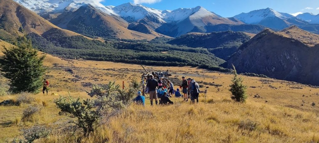
Once the second group had boarded, we settled down in comfort for the long journey to our destination. As we approached Porters Pass, the weather looked like it might come into play with swirling mist covering the valleys. At the top we were greeted by bright sunshine but this was short lived, prompting our President to make an important announcement culminating with, “It remains to be seen if we will see anything.” Not up to his usual erudite standards, but we all knew what he meant, and all bets were off on what we would encounter when we reached the start of the track. We were mindful that when the Club last tackled this walk three years earlier, it had quickly become a miserable experience with the only view being of our boots, and the rear profile of the person in front. Heavy rain falling before and during lunch had contributed to a less than memorable day. Not so this year. We started out in cool, calm and clear conditions allowing us to enjoy the beautiful bush, tussock, board walks and glimpses of the mountain tarns. Vast views of the Waimakariri and the surrounding hills reminded us of what a great part of the world this is, and how fortunate we are to have the health to enjoy these experiences.

On reaching the Bealey Hut, we quickly perused the sparse interior that in 2018 had provided such a welcome refuge (for some). This year we contentedly settled under the trees for lunch, occasionally glancing up hill, pondering how far we would be able to climb before we had to turn around. Victor arrived shortly after, clearly of the opinion that being able to complete a hike was a perquisite of his job! About then we learned that those with prior experience of the area had decided that with the late start, it wasn’t viable to continue further, and after a leisurely lunch we would return to the bus. Just as we started downhill the Alternates turned up – all smiling, and clearly having enjoyed the trek and views as much as the Standard group.

On the downhill trip we had more time to admire the flora, and who knew that toadstools came in such a variety of shades and patterns? Being quickly disabused of the notion that we should forage with a mind to having “Pollo Al Vino Bianco Con Funghi” for dinner, only photos were taken and the brilliant red-capped toadstools were left for the Alternates to admire in their turn.

Having reached the bus, the day was pleasant enough to lounge on the grassy bank expecting that we would have about a 40-minute wait for our club mates. With only one newspaper being in evidence, the owner thought she might be able to cover the day’s expenses by auctioning off the various puzzles (with pen), but no takers! As always, there were more than enough interesting conversations to occupy the time. It didn’t take long for the sand flies to find us, and we did wonder if the sight of Victor in the bus with the door closed meant that this was one aspect of New Zealand’s great outdoors that he hadn’t fully embraced. Just as we thought the voracious insects might actually win the day and force us to join Victor in his indoor sanctuary, the Alternates turned up and it was all aboard for home.

What a great day, and well worth the long bus ride to get there. Arriving at Bishopdale it seemed that during our absence autumn had fully arrived in Christchurch with swirls of leaves blowing across the carpark. Perhaps, next year if the stars align, we might be able to conquer Bealey Spur.
Craigieburn Forest Park 24 March 2021

Group

Leader

Mentor

Under Study

Tail Ender

Standard

Dave R

Chris

Alternative

Ray

Leonie

The bus ride to the mountains had us wondering if we would be walking in the rain but we enjoyed the perfect tramping day under windless cloudy skies.  President Keith welcomed visitors Basil, Joanne and Charley and Margaret Sc treated all 43 of us to chocolate eggs in celebration of her birthday. Delicious!!

Although Victor dropped us beside Mistletoe Track, both Mentor Chris and Leader Dave carried on up to the Luge Track (nothing like a bit of a change!) which climbed uphill to meet the Mistletoe Track.  There were 21 of us in the Standards Group enjoying the beech forest with hanging lichen punctuated with 8 scree areas.  The outlook from the scree was amazing as we were high up and looking down steep slopes with a few bright trees and slits cut into the forest on the opposite hills.  A few brave non-height lovers negotiated the screes without gazing downwards and managed to cope with morning tea and lunch perched on the edges of the scree.

After lunch we walked down to the Craigieburn Ski Area which has been in existence since around 1950.  It is recommended for intermediate and advanced skiers and has 3 rope tows. We caught up with the Alternative Group as we walked down the ski access road back to the bus.

Craigieburn Forest Park is a 447km2 protected area adjacent to Arthur’s Pass National Park.  D.O.C. carries out administration for conservation and regulates commercial activity. Broken River Ski Area and Craigieburn Valley Ski Area are within the borders.  Txt by Nicky

Peak Hill 17 March 2021

Leader Mentor Understudy Tail Ender
Standards Alan H Alan N Jan Barber Ali M
Alternates Liz S Gavin Ray Kiwan

Distance: 9.5km (Stds), 4km (Alt)
Duration: 5hr 35min (stds), 4hr 50min (alt)
Elevation: Max Alt 1253m (Std), 1039m (Alt)
Min Alt: 603m  Ascent: 650m (Std), 424m (Alt)

A group of 32 trampers set off with one of our regular drivers, Victor, on a clear sunny morning towards our challenge for the day, to climb Peak Hill.  Chris, as past, past, past President (or maybe more pasts) welcomed everyone including our four visitors: Sophie, Basil, Charlie and Veronica.  After encouraging members to sign up to the vacant roles for this and the next few tramps and writing of the diary Chris was pleased to see more of these roles filled by the time the forms had been circulated a couple of times. 

Two hours after leaving Bishopdale we arrived at the Peak Hill carpark.  We got our packs on and split into two groups of 16 people ready to follow the poled route across private farmland and over the stiles onto the hill, climbing through matagouri and celmisia scrub to the ridge.

The standards climbed steadily up to the top of the first ridge where everyone was pleased to stop by the information board for  morning tea.  Being  St Patrick ’s Day, Marie-Therese celebrated by wearing a green wig until the climb caused her to start to overheat.  Refreshed after our break we continued on, realising as we thought we were heading to the peak, that no, there was another and another!  Our driver Victor passed us easily as we stayed together as a group and was at the top enjoying his lunch long before we arrived. 

As we stopped along the way a discussion took place on what is the difference between a Mountain a Hill, a Summit or a Peak.  On checking “Google” it would seem the difference is vague and can be used interchangeably but there is still some difference in the literal meaning of these.

A mountain is generally a huge form of land which has uplifted above the surrounding land and its elevation is steep. Whereas a hill is a land form that extends above the surrounding terrain and is generally less tall and steeper than a mountain.

A Summit is a point on a mountain surface that is higher in elevation than all points immediately adjacent to it. Whereas a Peak is the pointed top of a mountain. The distinction between the Summit and the peak is unclear and largely subjective. Most of the time they’re used interchangeably. Peak requires the pointy shape though, which is part of it. Summit is the very top and is not defined by a pointed shape. It just means the very top.  A mountain may have multiple peaks but there is always one Summit.

While Victor headed back down the way we had all come up, the standards continued along the ridge admiring the stunning views to the confluence of the Rakaia, the Mathias and Wilberforce Rivers on one side and Lake Coleridge on the other.  Looking for the old fence on our right we eventually found our way to the corner of the Conservation land, headed left and followed the fence back along the end and the river side of the hill.  About half way along there is a new poled route through the matagouri, bracken and Spaniards.  This route has been partially cleared but is still somewhat challenging under foot.  We finally got to the top stile and headed back down over the farm land and the waiting Alternates and the bus.

Everyone was pleased to have enjoyed great weather and to have made the climb to see some of the best views of any tramp we do.  We knew we were not going to make it home to see the America’s Cup race on TV and agreed not to talk about what we saw/heard on our phones to allow the result to be a surprise to those who wanted to watch with bated breath.  It turned out to be a day of celebration as NZ retained the America’s Cup!  Text courtesy Jan Bbr

As an aside, I remember a School Journal story about how the Lake Coleridge Power Station (and therefore the power supply) was cut off by a great snow storm in 1918 and the mission to get the power back on.  I found a reference to it at: https://thespinoff.co.nz/partner/objectspace/14-11-2018/the-single-object-a-quest-for-a-set-of-heroic-skis/ .  There was some debate about Boris using Captain Scott’s skis to save the day! (Chris)

Glenafric 03 March 2021


  Leader Mentor Understudy Tail Ender
Standards Peter Jan Bb Jan Ba Margaret E
Alternates Richard Ian Barb G Kay

New Driver Tony whisked us away north from the city while President Keith welcomed visitors: Basil, Veronica and Joanne then handed around treats as a thankyou from Janet.

There is always something special about a farm tramp.  Perhaps it is the fact that the general public cannot experience it.  Glenafric, as leader Peter says, is one of the best due to the variety offered in a few hours.  There is something for everyone from the first steady climb off the bus to the final climb up from the beach.  Both the morning tea and lunch spots had outstanding views over the farmland and the sea respectively.

The track was dry, as were the fields, in fact they seemed parched.  Navigating farmland is never easy but generally we headed in the right direction.  The stream in the valley was crossed several times with some getting wet feet.  There were interesting land formations and matagouri and grass just above the ocean.

Once on the beach (standards only) a great deal of fun was had rock-hopping and looking for fossils while the sea beckoned on this warm, almost windless cloudy day.  Both groups of 21 enjoyed the day and both had a loss but later found situation, so Bill and Ian were happy too (wallet and glasses).

Later this year work will start on the Mt. Cass Wind Farm, a $200 million project involving 22 turbines which will produce electricity for 40,000 homes (93MW). It will be the biggest wind farm in the South Island and the largest locally owned farm in N.Z.. The turbines will stretch 7.5km across peaks Cass, Totara and Oldham and will use the GE4.2-117 turbines for the first time in N.Z..  Protected long-tailed bats have been found near the proposed wind farm so Main Power is in consultation with D.O.C. at present.

Next year our trip to Glenafric may include sightings of these amazing new turbines!!!!!      Diary text by Nicky

Mt Oxford / Ryde Falls 17 February 2021

Group                 Leader             Mentor           Understudy              Tail Ender

Standard            Alan                  Keith               Jan Bbr                       Judy

Alternate          Min                    Wendy            Linley T                      Leonie

Distance:  14km   Time: 6 hours 18 minutes  Ascended: 1070m    Descended: 1070m

It was a perfect day for what is probably the toughest tramp in the BTC schedule.  Cloudless, no wind and about 19C predicted.  The Alternates were doing the Ryde Falls tramp and as the two groups separated almost immediately on alighting from the bus, separate journal writers were assigned.

Once aboard the bus, President Keith advised that we had 29 members in attendance and that Basil P was again a visitor for the day.  As we were at Alert Level 2 again, masks were worn on the bus. The North Canterbury countryside was sparkling in the morning sun as we travelled up Tram Road.   Oxford (without the dreamy spires of its UK namesake) is looking prosperous these days and we stopped to soak up some atmosphere as well as to derive some comfort from their public conveniences.  It is only a short drive from Oxford to the start of the Ryde Falls/Mt Oxford tramp at Coopers Creek and by 10am both groups were on their way.

From the bus, the sight of Mt Oxford towering over 1.3km into the air is a daunting prospect but fortunately we had about a 300m start at Coopers Creek, reducing the climb to just over 1000m.  When the groups separated, 9 hardy trampers remained in the Mt Oxford group, none of whom had done the climb before.  The question was posed…..what did those who had summitted before, know that we didn’t know?

Leader Alan set a steady early pace across the flat land and into the well blazed track up the beech-covered slopes, with morning tea taken in the beech-filtered sun after about 40 minutes.  On the way we had passed dozens of beehives but despite these bee numbers, the wasps were dominating the honeydew collection from the black beech (nothofagus solandri) trees. This honeydew is produced by a small-scale insect that lives in the bark of these beech trees. These insects have a very simple body structure, and they insert their mouths into the tree and extract the nutrients they need to survive.   However, they extract more sugar than they need and so excrete the surplus sugar through their anal tubes and this provides the drops of clear sugary liquid which sparkle in the sunlight. They are ok to eat!   Unfortunately, the wasps were busy and we were keen to avoid being stung.

The track through the beech forest is unrelenting in its upwards slope, very steep in places, and it is surprising how high the beech forest extends up the hill.  It was 2 hours before we emerged into the sunlight and the sub alpine scrub;  dracophyllum, hebes, tussock etc   It is always a sudden change of scenery when one emerges from the bush and on a day like this it was stunningly beautiful.  Onwards and upwards we strode but now we had the splendour of a panoramic view across the plains, whenever one could manage a glance up from the concentration of negotiating the rocky track.  At one point, our Leader Alan provided an interesting geology lesson, having noted some volcanic rocks which were glinting in the sun.

There were some very steep pinches above the bush line as we headed up to what appeared to be a communication tower of some sort on a peak ahead.   We hoped this was the summit.  It was, and the views on reaching the top after 3 hours of grunt, made the effort well worthwhile.  To the east, the Port Hills in the distance were shrouded in mist while immediately to the west was the flat grazing land of the Lees Valley.  To the south, the road up to the Cheeseman ski field was visible with a couple of wisps of snow in valleys on the higher slopes.  Lunch was taken in beautiful conditions with now just the slightest puff of a breeze. Mandatory photos were taken, including, after several ‘takes’, a successful group photo using a timer, when the first one taken was a ‘selfie’!    Amongst the tussocks there were some bright white flowers, contrasting vividly with their brown background.  Subsequent analysis suggests these are gentians.

There was some apprehension amongst the group about the steepness and footing on the descent as we all headed down carefully following our leader, who appeared to be skipping down in places.  It took us 2 ½ hours to get back to the bus so our descent was not much quicker than the ascent.   At several points on the way back through the beech forest, Kay and the writer got cramps (not writer’s), and in each instance Kay’s miracle spray brought about a rapid recovery.  Nicky also sustained a cut on her leg when she lost concentration for an instant and had a small fall off the track. The Ryde Falls group were there when we arrived back but we hadn’t kept them waiting very long.  As we looked up at Mt Oxford from the bus there was a sense of satisfaction that, in the words of Sir Edmund, we had “knocked the bastard off”.   txt by Selwyn

Lake Rubicon 10 February 2021

Group

Leader

Mentor

Understudy

Tail Ender

Standard

Peter

Alternative

Distance(s): 13.69/11.78kms           Time Walking: 4hrs 49mins

Elevation: Max Alt 759m      Min Alt 464m      Vert Ascent: 400m

It seems that as one, the 34 trampers who had signed up for this hike rose early to check their computers for the cancellation which should have just been a formality.  But no communication from HQ, and as we all made our way through the pouring rain to Bishopdale, the aura of invincibility surrounding our weather team, had definitely taken a hit. With the rain somewhat diminished but still “heavy”, the money was collected on the bus and off we set for the bedraggled and forlorn group waiting at Yaldhurst. As the bus ate up the kilometres the glimmer of lighter grey sky to the west lightened and grew, until suddenly we were in sunshine, and the reputation of the aforementioned team once again shone equally brightly! 

Arriving at our farm destination, Peter signed us in and we all looked forward to our day which had started with so little promise. There had been a bit of a scramble to fill the various leadership spots but confident that everything was sorted, both groups set off. It was wet underfoot and the first hurdle was to be faced just a few minutes into the tramp. The boggy stream didn’t appear too intimidating but one of the group found herself “half a club length” short of clearing the gap. There was plenty of long wet grass around to wipe away the mud and no harm done.  As we walked along there were several comments along the lines of “I don’t remember this part” but with just enough inclines to keep us honest we were soon enjoying morning tea and the surrounding vista. Although there was a general consensus that we weren’t where we thought we should be, Pete assured us that he hadn’t put a foot wrong, his comment somewhat undermined by the mentor’s, “This is all looking a bit dodgy”.  By way of motivating the troops, Pete informed us that there were three hills to go before lunch from where it would be just a stroll back to the bus. Having knocked off the first of the hills, it was disconcerting to learn that that incline had not met Peter’s definition of a “hill”, and by his reckoning there were still three to go!  By now it was apparent that the standard group of 16 trampers wasn’t entirely sure of the route, and we were quite pleased to not once, but twice, “bump into” the alternates where their leader Bruce was able to point out roughly where our group should head. In due course we encountered the sheep track that sidled round the hill through scrubby trees which we all recognized. Later we learned that one of the alternates had tramped with a set of loppers – was it to help his companions through this stretch unimpeded? If so, what a star and we could have done with some loppers ourselves as care had to be taken to carefully hand off branches to those coming behind lest they have the smile wiped off their faces in the worst way possible!

Lunch was eaten at our usual spot overlooking the lake. We had no sooner sat down in reasonably balmy conditions when the wind got up and it blew with such force that it was a struggle to keep the tea in the cup. We also noted that on the lake the water was rippling in one direction and the reeds blowing in another. 

A hasty call to end the lunch break was warranted and as promised, the hard yards were behind us. Once we had carefully navigated our way around the end of the lake, it was just a stroll from there on. Fortunately, we didn’t have to battle into a head wind as we walked to meet the bus which we encountered coming to meet us! How thoughtful!

Time allowed a stop in Darfield and swapping stories over a coffee, beer or ice-cream was as enjoyable as always.  Arriving back at Bishopdale, the weather proved to be the opposite of how it had been when we left.  We were grateful to the weather team for once again getting it right and allowing us to enjoy another good tramp.  

Text by Jan Ba.

Mt Alford 3 February 2021


  Leader Mentor Understudy Tail Ender
Standards Jan Ba Chris Keith Jan M
Alternates Peter Norma Liz Margaret S

 After leaving clouds and traffic woes in Christchurch [a crash on Bentley St had delayed the bus by about 25 mins], Victor our driver deposited us at the Mt. Alford carpark in sunshine where our intrepid leader, Jan Bb, began the tramp up the D.O.C. track.  This was her first ascent!!!!  Earlier President Keith had welcomed 44 trampers including visitors Sophia and Moira after handing round chocky treats courtesy of Alan H’s reaching a significant birthday milestone.

Mt. Alford was named after Lord Alford who was a member of the Canterbury Association formed in England in 1848 to organise emigration to establish Canterbury and capital ChCh in N.Z.. This started in 1850 but was not a financial success for the founding members and so wound up in 1855.  Lord Alford died in 1951, aged 38.

The tramp was a mix of bush, tussock and subalpine shrubland. The bush was wet in parts which suits the lowland totara and kahikatea. Apparently the settlers felled many trees in this area.  In 1882 it was thought there were diamonds here.  Mining companies and prospectors applied for licences and a settlement called Diamond Town was laid out.  However the diamonds turned out to be crystals and so it was back to felling timber. Happily several species of small birds live in the remaining bush today although we didn’t hear much birdsong.

The soft golden tussockland greeted us as we came out of the bush and the views over the plains and Ashburton River on one side and the Pudding Hill Range on the other were splendid.

Climbing up along a fence line in subalpine shrubland popped us over a hill to see a white globe (observatory) peeking over yet another hillside. This was one of those tramps where there was yet another “summit” before the top.  A rickety picnic table was the alternatives lunch spot but we continued up on shingly stones almost to the ridge where we lunched with amazing views spread out before us. Clouds in the distance looked like mountains with the white ones peaking the grey.

Unfortunately our late start caught up with us and we joined the alternatives on the way back to the bus.  Perhaps we’ll make it to the top next time!!!  Text by Nicky

Rakaia Walkway 13 January 2021

Rakaia Gorge Walkway 13 January 2021

Leader Mentor Understudy Tail Ender
Standards Bill S Peter Jan Br Ali
Alternates Liz Norma Margaret S Eric

Distance: 10. 40km
Time Walking: 3hrs 4 minutes
Elevation: Max Alt: 443m Min Alt: 295 m Vert Ascent: 414m

A group of 43 enthusiastic trampers stepped off the bus at the Rakaia Gorge Bridge for the first walk of the season. There were no visitors joining us on this tramp.

Weather conditions were perfect with clear skies and very little wind. Once organised, both groups set off on the gorge track which takes in the historic Ferryman’s track.

When European people started settling in Canterbury, an Accommodation House was built by the Rakaia Gorge by John Bryan, in 1851. It included a smithy, post office, bar and cattle yards. It burnt down in 1878 and was not replaced, but while Bryan was there he ferried travellers, stock and goods across the river in a flat-bottomed punt pulled by a rope from the other side of the river. The accommodation house was on a terrace on the north side of the river

The forested track follows the contours of the river allowing plenty of views of the winding turquoise river below. Recent maintenance of the track was evident with fern leaves and other cuttings littering the path.

At the morning tea stop by the lookout above the river, most people elected to find a spot in the shade rather than take in the views. Luckily, there were still plenty of spots in the shade when the alternatives arrived.

Carrying on along the track we passed the sign indicating the Snowden Mine. Some Trampers had previously taken the short detour to visit the mine, but not on this occasion. The mine site was developed by George Gerard in the late 19th century for local coal use.  Gerard owned the Snowden property the mine was sited on.  All mining was ceased by 1904.

Reaching a sign posted junction on the track, the alternatives would carry on downhill to a lunch spot on the banks of the river, while the standards took the longer steeper track to the right, before dropping down to the river. While walking uphill we encountered a flock of sheep which looked like they were being herded downhill, and we all moved aside to let them pass. It turned out it was just two people walking the track behind them, and with an even larger group of people in front, the sheep decided to turn off and go down the bank before they got to us

Reaching the lunch spot by the river there was enough of a breeze to allow us to sit in the sun if we chose to. A bit more padding would have made it more comfortable though. A few people decided the cool water looked so inviting, they enjoyed a quick paddle in the shallows.

After lunch both groups made their way back to the bus on the shorter route.

There was plenty of time for a refreshment stop on the way home and the decision was made to bypass the usual stops and instead call into the Yaldhurst Hotel, which the manager there had suggested might be a nice idea since we were using their car park. The two women behind the bar coped well with the 40 odd arrivals, and everyone quickly got their drinks. Then it was back on the bus for those travelling on to Bishopdale, while the others returned to their cars.

Everyone agreed that it was a great start to the 2021 tramping season.

Text courtesy of Sally.

Poet’s Corner

A Poem:

Flowers Track for starters from Sumner we did climb,
The day was curtain clouded with the weather promised fine,
Captain Taylor in his schooner made an obvious mistake,
As we trod the sandy beachfront leaving footprints in our wake.

Out to the remnants of a war that never came
With gun emplacements silent, wooden barracks still the same.
Richard told a story of the reason for the site,
To protect the eastern Aussie shore from Japan’s  naval might.

Enough of this nonsense, regards Terry.

1st July 12.00pm Birthday Party & AGM

page1image9725904

Bishopdale Tramping Club invites you and your partner to our 35th Birthday party!

This event will be held on Wednesday 1st July at the Quality Hotel Elms, 465 Papanui Road.

  • Buffet Lunch & AGM 12 noon.

  • Enjoy a presentation about The Old Ghost Trail.

  • Booking & Payment ($40) by 25th June.

  • Payment to BTC account no. 03 1702 0089032 00 with your name as reference.

  • Payment can be in cash to Norma.

  • No bookings or payments on the day.

  • RSVP by 25th June please.

We look forward to seeing you there!


page1image41432960 page1image41432576 page1image41430656