Tree Planting & Port Hills Walk 9 June 2021


  Leader Mentor Understudy Tail Ender
Whole Group Nicky/Norma Norma Judy Ali/Eric

Were this report to be only one word, it would have to be ‘variety’: a variety of weather; a variety of activities; a variety of plants; a variety of road conditions; a variety of tracks; and variety in our return route to Bishopdale Mall car park.

On a beautiful, sunny, winter’s morning, a group of over 30 planter trampers gathered at Bishopdale Mall car park to board our coach bound first for Princess Margaret Hospital to pick up the balance of our 47 trampers for the day’s activities.  However, our trip to PMH was very slow because we ‘copped’ every red light on the way and long queues at some of those lights so there were a few lights’ phases before we got through.  We did not arrive at PMH until after 9.00 am to be met by a group of rather cold trampers because the weather there was 100% grey overcast.

The coach driver, Viktor, then took us up Hackthorne Rd and Dyers Pass Road to the planting site in Thomson’s Reserve – the first time that the club had been tree planting there was in 2001.  The latter part of that short drive had its challenges!  Because of extensive road works, including two further (temporary) red lights, Viktor had quite a challenge negotiating the red cones forming a single-lane slalom to the Sign of the Kiwi corner – spontaneous applause broke out at this point to mark Viktor’s success.  In the cloud around the parking area on the Summit Road at 10.00 am, we were met by three city park rangers who had, on the previous miserable day, prepared the planting site.  As a result of their efforts, 420 seedlings of various native species were waiting for our tender planting efforts.  After a demonstration on how to dig a hole and plant a seedling by the ex-Glaswegian of the ranger trio, armed with spades, we took to slope with gusto.

At each appointed planting spot, there was a bare, fairly flat spot, a seedling in a pot, a cardboard rectangle, three stakes and protective netting.  The soil was damp enough to be dug reasonably easily, except if one struck an odd stone or two.  After carefully placing the seedling, and back-filling the hole, the cardboard rectangle was placed around the plant’s stem and covered with mulch.  There was a difference of opinion among our supervisors over the better way to lay the two available mulches: dead grass first with commercial bark mulch on top or vice versa.  After 50 minutes, the lead ranger, Fiona, who is well known to club members, said we could have a break for ‘smoko’ (not a commonly used term in this non-smoking age!) and though some accepted the invitation immediately, others were determined to finish the planting at the first position before taking a break and stayed till that was achieved.  During the planting, the grey cloud began to break up a bit and some faint rays of sun returned.  After the non-smoking ‘smoko’, planting resumed at a spot slightly higher up the slope.  Within 30 more minutes all plants were firmly in the ground – 420 plants in 1.5 hours compared with 2020, when, under Covid-19 restrictions of only two groups of 10 planters could work, a similar number of plants took 4 hours work to plant them.  The plants were all eco-sourced, which means that they had been produced from plants growing naturally in the ecological area of the Port Hills.  There were 18 indigenous species among the 420 plants, including four species of Coprosma. We also planted some specimens of the widespread endemic kanuka species, Kunzea robusta (botanical taxonomists now recognise 10 species of kanuka in this genus; all of them have a ‘Threatened’ status, seven are ‘Nationally Vulnerable’ and three are ‘Critical’).  The tree seedlings planted were totara, Podocarpus totara.  Those club members who have been on a number of tree-planting days commented favourably on how well some of their previous efforts had succeeded.  Cabbage trees (tῑ kōuka, Cordyline australis) certainly seemed to have made significant progress.

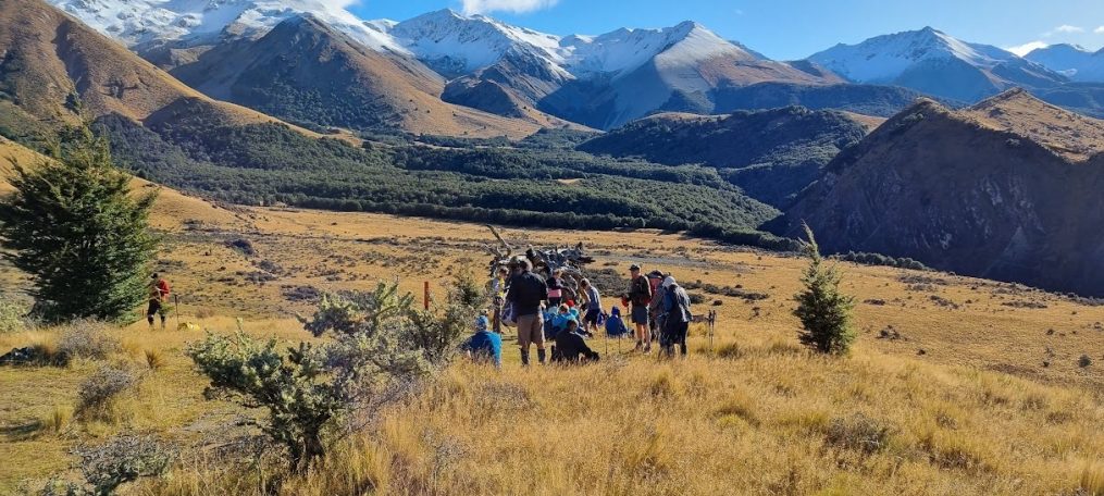
The ’work’ part of the day complete, as one large group led by Nicky, we went round the west side of Sugarloaf and down to the Sign of the Kiwi, which is currently closed because of the road works.  However, all the outdoor seating and tables were there so we spread out to have an early lunch and enjoy the weather that was continuing its improvement until the cloud returned.  Back across the road, we followed the track round the south side of Sugarloaf and continued eastwards along the Crater Rim Track towards Mt Vernon.  At this point, we had a ‘high road’ and a ‘low road’; Norma took the Alternatives on the low road while the Standards took the ‘high road’ to Mt Vernon’s summit.  The two groups coalesced again for a while on the sloping track down from the Summit Road before another ‘low road, high road’ split.  As on the first occasion, and unlike the well-known Scottish song, the low roaders got to the destination first, but as was overheard on the coach (in another context) “It’s the journey not the destination”.

But the day’s variety was not yet finished.  After dropping off the PMH group, we were taken to see where our coach spends its time while not taking people around.  Viktor loudly tooted the bus’s horn to his colleagues as we passed the Leopard coach depot in a road probably few of us had ever travelled on.  Txt courtesy of Eric & Margaret
Mt Vulcan 2 June 2021


  Leader Mentor Understudy Tail Ender
Whole Group Peter Leonie Jan Bbr Paul

BTC reports of previous Mount Vulcan walks make for dramatic reading. They include The Great Fog of 2017, and The Great Escape of 2020 (the first day out after months of Covid-19 lockdown).

On May 28, 2021, the MetService issued a red alert for Canterbury. Between 200 and 300 mm of rain was expected between Saturday afternoon and Monday mid-morning. The predicted rainfall  for the high country in the Mt Somers and Alford Forest area was significantly underestimated with 551mm falling over Saturday and Sunday.  The days following included tales of raging torrents – both branches of the Ashburton River burst their banks, daring rescues and accounts of devastating damage and loss.

We were glad to be going north.

Many of us were expecting mud and perhaps some were put off at the prospect of it. As many as 10 ? waitlisted people made it onto the bus (47 in total including 2 visitors: Chris H and Alister). On the way Coordinator of the new online booking system Dave Bastin reminded us to contact him if we have any difficulty navigating our bookings.  We crossed swollen rivers, marvelled at the greenness and wondered at how quickly North Canterbury land had dried out.

We walked in one group over undulating farmland – with very little mud. The sky was blue and still and almost balmy. It’s limestone country and apparently there’s a quarry on the farm. There’s also a massive landslide, known as the Montserrat earthflow for which the Little family  (who’ve farmed the land for 125 years)  initiated a QEII Conservation Trust covenant.  We saw beehives and bees out working. Our morning tea stop was observed by a flock of sheep and our walking was occasionally accompanied by the quardle oodle ardle wardle doodle of magpies.

We lunched on the slopes and top of Mt Vulcan (135 metres) which affords a fabulous 360-degree view from alps to ocean. To the east is Motunau Island. Motunau means ‘island of the nau’. Nau grass (Cook’s scurvy grass) is a coastal cress. The island is also home to the only colony of coastal based white-faced storm petrels between Cook Strait and the Otago Peninsula.

The enjoyable walk down to the bus with driver Victor joining us along the way was punctuated with stiles and gates. On our return bus ride President Jan Barber announced that Selwyn Maister had won a Sporting Legend Award at the recent annual Canterbury Sports Awards. Selwyn was resoundingly congratulated.

It was  a shortish walk with plenty of time for refreshments at Amberley on the way home.  Txt by Jen

Tramping Programme 7 July 2021 – 29 September 2021

07 July        12 noon         Birthday Lunch, The Elms, Papanui Rd

Cost: $42.50       Members refer to invitation        Payment by 28 June

 14 July      8.30am   Working Bee Flagpole

As with Coalgate the main job will be removing debris from fences. There are some fences close to the house and others further away, so likely we will split into two groups.

  • You will not need any equipment – Warrick will provide any tools that might be useful.
  • Bring gloves, overalls or clothes that you don’t mind getting dirty, gumboots or boots/shoes.
  • Morning tea, lunch, change of shoes as per normal plus a change of clothes if required.
  • Pick-ups will be Bishopdale and Yaldhurst

Bus fee will be $20

Please use the standard booking sheet to indicate your availability.
Many thanks for your enthusiasm to support our farmers, who support us.

21 July      8.30am

Monument – Mt Herbert – Diamond Harbour Domain

A steady climb to the summit of Mt Herbert with some sections of the track being steep and quite long. A long descent to Diamond Harbour township and the Memorial Gardens.

Stats: distance 13.2km, ascent 1373m, time 4hrs 30mins

Cost: $20            Alternative Pickup: Halswell

28 July                8.30am               Huntsbury – Mt Vernon Park

Standard route: From the top of Huntsbury Avenue, follow various tracks to Sign of the Kiwi, Sugarloaf and Mt Vernon, eventually descending via Mt Vernon Farm Park and Bowenvale.

Alternative route: As above but not over Mt Vernon.

Stats: distance 12.8km, ascent 500m, time 4hrs 15mins

Cost: $10            Alternative Pickup: PM Hospital

04 August           8.30am               Dracophyllum Flat

Standard route: Tramp through beech forest and alpine pasture following the cycle trail almost to Texas flat, then across country via a crossing of Broken River to Highway 73.

Alternative route: Follow cycle trail to Texas Flat, then via the Cheeseman Ski Club access road to the Broken River Bridge on Hwy 73.

Stats: distance 13.6/12km, ascent 254m, time 4hrs 30mins

Cost: $20            Alternative Pickup: Yaldhurst

11 August          8.30am               Pegasus/Waikuku to Kaiapoi

A gentle coastal tramp including beach walking.

Alternative route: Walk south along the beach or follow the Pegasus Walkway to Woodend Domain for morning tea. Take the Pegasus Walkway to Pines Beach/Kairaki and then along Waimak/Cam river stop banks to Kaiapoi.

Standard route: Walk Waikuku Surf Club to Pegasus then same as Alternatives.

Stats: yet to be recorded

Cost: $15            Alternative Pickup: Adjacent to Coastguard building Charles St, Kaiapoi

18 August          8.30am               Charteris Bay – Purau, and return

Some short steep climbs on inland rural and urban roads to Purau, with the return to Diamond Harbour along the undulating coastal margin walking track.

Standards continue on the coastal path to Charteris Bay pick-up.

Stats: distance 14/9km, ascent 153m, time 4hrs 30mins

Cost: $15            Alternative Pickup: Halswell

25 August          8.30am               Little River to Birdlings Flat

A road walk with steady climb to ridge, along Bossu Rd and down to Birdlings Flat.

Alternative option: As above but starting at top of Kinloch Road.

Stats: distance 17.7km, ascent 600m, time 4hrs 20mins

Cost: $20            Alternative Pickup: Halswell

01 September   8.30am        Princess Margaret Hospital to Huntsbury

Moderate climbs and descents on streets and tracks through Victoria Park to Sugar Loaf and Huntsbury.

Stats: distance 14km, ascent 400m, time 4hrs 50mins

Cost: $10            Alternative Pickup: N/A

08 September   8.30am                Barnett Park – Pony Point

A mixture of gradual and steeper climbs and descents between Barnett Park and Pony Point. Both groups together from lunch.

Stats: distance 15km, ascent 568m, time 4hrs 30mins

Cost: $15            Alternative Pickup: Windsurf Area, Humphries Drive

15 September   8.30am                Dry Acheron

A mixture of flat grasslands, moderately graded natural stream verge, rocky dry stream beds and many stream crossings.

Stats: distance 13.4/12km, vertical ascent 280m, time 3hrs 45mins

Cost: $20            Alternative Pickup: Yaldhurst

22 September   8.30am                Mt Thomas

A steepish steady climb all the way to lunch, then downhill to the bus.

Standard Route: Up Ridge Track to Hunter Hill then along the ridge to the summit of Mt Thomas, returning via the Wooded Gully Track.

Alternative Route: As above with the option to go down the Wooded Gully track or continue to Mt Thomas and return down the Summit Track (very steep).

Stats: distance 15km, vertical ascent 790m, time 5hrs 45mins

Cost: $20            Alternative Pickup: Lineside Rd by ‘Please don’t litter’ sign

29 September   8.30am                Hogsback Track – Castle Hill

Standard route: Tramp along an undulating mountain bike track from Castle Hill Village to the western end of Hogsback Ridge.  After lunch on the ridge and return along the same track.

Alternative route: As above but stopping for lunch along the track as suits.

Stats: distance and ascent yet to be recorded, time 5hrs

Cost: $20            Alternative Pickup: Yaldhurst

Weka Pass 26 May 2021


  Leader Mentor Understudy Tail Ender
Standards Dave Chris Nicky Margaret E
Alternates Nick Norma Linley M

A clear but overcast sky as we left Christchurch heading for a foray into the limestone country of North Canterbury.  With 46 on the coach, driver Viktor turned left at Richard Murchison’s Weka Pass Farm homestead on to the winding, shingle Fergussons Road.    An early Cobb and Co stage-coaching hotel sat in front of the old house there in the 1860s. The first licensee was Joseph Ward who ran the hotel and a 60-acre farm as well as looking after a toll gate there.

Out of the bus, we were met with a hard, cracking frost so it was smartly over the bridge and steeply (at first) up the farm track above the creek to a rolling limestone ridge.  Morning tea was taken higher up the hillside where we had great views over the top corner of the farm and out to the plains of the Waipara basin’s limestone terrain.

With morning tea over, we worked our way along the topmost ridge overlooking the middle of the farm and where we would be shortly tracking.  The north-easter today had a bite to it as we followed the fenceline to the end of the ridge.  With a careful sidling descent off the rocky knob, we proceeded to the deer paddocks at the bottom.  With the gates already kindly unlocked, we moved on to the main roadway through the farm.  Fortunately, the group of wary yearling stags in residence had retreated to a far corner out of sight.

Now it was a gentle meander up and down the farm road through patchy scrub and green hills, but fortunately most gates on this stretch had been left open.  Across the creek with mostly dry feet, we climbed the gentle inclines to the lunch spot – the haybarn that is almost halfway through the journey.  At least we could gather where there was some sun and a modicum of shelter from the breeze.  Under the clear sky, the imposing limestone escarpment above us echoed citadel walls and crusader sieges, or perhaps the jagged backbone of some ancient Mesozoic sea creature poking out of the landscape.  More of the same easy farm road and paddock walking continued after lunch but with this were a few more gates to open. Permafrost lingered in the shadows, so cold feet were avoided by staying in the sun.

Richard’s northern boundary is alongside the ghost of the old Weka Pass coach road, which we followed.  As we ambled gently up the slope, it was not difficult to reflect on what the coach journey must have been like for travellers back in the early days or the countless numbers of gold seekers on foot off to the west coast diggings via Harper’s Pass.

With the Alternates finishing not far behind us, there would be time for refreshments at Amberley on the way back to Christchurch.  Despite the cool conditions, you could still say it had been a enjoyable tramp. Txt by Chris

* We are pleased to report that the alternative tramp today from the Sign of the Takahe and return went very well. We departed at 9.30am with 10 trampers and finished at 2.40pm having descended to the Heathcote River, followed it downstream for approximately 2 kms, ascended Hollis Ave and walking track to Longhurst Tce, and lunched at Cracroft Reserve adjacent to the Sign of the Takahe. After lunch 7 elected to continue to the Sign of the Kiwi and return. Txt by Bruce

McCormacks Bay – Evans Pass – Moncks Bay 19 May 2021

  Leader Mentor Understudy Tail Ender
Standards Nicky Chris Alan Ailsa
Alternates Nick Ray Norma Terry

Stats: distance 15km, vertical ascent 676m, time 5hrs 20mins

A day with no wind, no sweltering heat or numbing cold, and best of all, little likelihood of mud. What could be nicer for our cheerful bunch of Bishopdale Trampers on such a pleasant day than a mid-week toddle on the Port Hills? Our driver Alan had got us safely (via the scenic Bealey Avenue route) to our starting points: McCormacks Bay for the 21 Standards, and a head-start up Mt Pleasant for the 22 Alternates.

We Standards briskly set out from Basil Place, up (and up) Drayton Track, past some scorched undergrowth and a lot of varied vegetation until we emerged onto Mt Pleasant Road.

Morning tea was at the start of the John Britten Reserve, at our customary picturesque spot with the stupendous views of … oh, since our last stop there, someone had dared to build new houses obstructing our view of the Alps and the city.

After more up, over and around the hills, the Standard Troupe marched resolutely up to the old gun emplacements, only to find this high ground was already occupied by the Alternate Brigade. No matter, the latter took off at the very sight of us, so we promptly decided to have an early lunch there even though it was by then only 11.30.

Single file, we walked along what were often little more than sheep tracks, over the typical Port Hills terrain of tufty tussocks and lichen-decorated rocks, with the occasional mountain biker flying past. It wasn’t long before we encountered the Alternates again, and we powered past them as they were enjoying their lunch beside the track- only to stop for a catch-up break as soon as we were out of sight.

Our meanderings had taken us past Jollies Bush, down a ridge to Evans Pass Road, and our route was so cunningly circuitous it eventually led us all the way back to just below where we had lunched amongst the gun emplacements. What had been achieved by all those kilometres in between?  The ever-changing vistas of course, each twist around the hillsides was like turning a kaleidoscope to completely change the picture … a view of Redcliffs quickly gave way to a flash of Lyttelton Harbour, a few more turns and we were enjoying impressive views of the city and those stunning snow-clad Alps.

The dry hillside terrain changed completely as we headed towards the built-up area of Clifton Terrace via the East Enders/Frog Pond track. One of the more remarkable sights we passed was a large wooden ark, a remnant of the once-renowned Gethsemane Gardens, now being transformed into a subdivision.

On the way down Clifton Hill, we enjoyed a sort of ‘House and Gardens’ tour as we gazed at some impressive (and sometimes munted) homes. Mulgans Track led us rapidly down to our bus waiting for us by the Yacht Club at Moncks Bay.

It wasn’t too long a wait for the Alternates, then we were all off to sample either the delights of the Heathcote Tavern or the best/worst ever café in Christchurch, at the rustic Heathcote Pony Club.

Txt by Shirley


Mt Richardson 5 May 2021


  Leader Mentor Understudy Tail Ender
Standards Glenys Janne Nicky Peter
Alternates Ali Bruce Leonie Linley T

On the north side of the Waimakariri River behind Rangiora are 3 sentinel mountains: Richardson, Thomas, and Grey. This week it was the turn of Mt Richardson to feel the stomping of the Bishopdale Trampers. Soon-to-be President Jan welcomed everyone including our Driver Alan who carefully negotiated the narrow road to the Glentui Picnic area and got 39 members plus 2 visitors (Jae Hyun and Alister) to the start at 10am. The weather was so unusually warm that many people removed their cold weather clothing layers at the outset.

Mt Richardson is 1047 metres so everyone knew that we had 2-3 hours of near constant climbing with stops for morning tea, changes of clothing and, of course, appreciating the scenery. The weather was ideal for the occasion: warm and a clear blue sky.

After half an hour both groups had morning tea but the top still looked a long way up. The honey dew sparkled in the bright sun, a stark contrast to the black beech tree trunks. Fortunately, the recent cool weather seemed to have quietened the wasp population and they were not their usual aggressive selves!

Mt Richardson is one of those tramps where the top looks close but it is always a bit further than expected. The reward for the grunt is an excellent place for lunch at the top looking down on Lees Valley. The Alternates arrived as the Standards were leaving so both groups were treated to a very close Bellbird in full song. It is amazing that a small nondescript bird can produce such a melodious and piercing sound. I look forward to the time and technology when we can include their song in the Diary!

The bellbird chorus accompanied the trampers along the Blowhard Track. It was though they were welcoming us into their world and we certainly enjoyed the walk on the mostly gentle downhill. After about an hour we turned onto the By Pass Track. The tail of the Standards stopped periodically to take samples of the flora for the interior decoration needs of one of the members!

In due course the Alternatives arrived back at the bus just as the sun went down behind the hill and the air cooled noticeably. Another great day on a North Canterbury mountain. Txt by Peter

Hill Top to Cooptown 28 April 2021


  Leader Mentor Understudy Tail Ender
Standards Alan Jan Bbr Gary Jan Brw
Alternates Bruce Norma Margaret S Min

Distance: 15.8km    Ascent: 728m   Time: 4hrs 30mins

It was a very chilly start for all 44 trampers but what an amazing tramp we had!!!  President Keith welcomed visitor Charlie and welcomed back Derrick after his long absence and recovery.

The standards alighted on the hilltop (heading for Akaroa) and walked down the road to the D.O.C. sign to Montgomery Reserve. Little did we know what a WOW factor walk this was going to be. The track wound up the hill quite steeply with some slippery leafy areas, giant stone steps and beautiful bush containing amazingly large totara trees and numerous papery barked native fuchsias. In fact, the first large totara we saw is about 2000 years old.

We popped out of the bush to find amazing views all around – Akaroa to one side with Pigeon Bay on the other and lots of rolling hills all around. It was a mind-boggling view to enjoy during morning tea.

Despite the biting wind we marveled at the landscape of skeleton trees and stumps weathered by the wind but not rotting as we moved across the rolling hills.  There must have been a beautiful stand of totara trees there at some stage. We headed into a scenic reserve and had lunch on a ridge with some shelter with views all around as we looked up Te Roto O Wairewa/Lake Forsyth.

After lunch we turned into a paddock (private property) just at the end of the reserve. The Alternates were here finishing lunch and we moved on ably led by Alan Harvey through natural markings (stark tree remains), crossed a stream and a few boggy spots. There was no obvious track but it was beautifully warm on this sheltered side. It was rather tricky to follow so Chris kindly went back to help the Alternates.

After the farm track ended we walked out on the road to find the bus.


Camp Saddle / Helicopter Hill 21 April 2021


  Leader Mentor Understudy Tail Ender
Standards Alan Chris Jan Bbr Selwyn
Alternates Ray Norma Wendy Leonie

Distance: 13.5/10.9km   Time: 5 hrs 15       Ascended:  850m      Descended:   850m

It was a perfect day for one of the favourite and most challenging tramps in the BTC schedule for the Standard Group – Camp Saddle.  The Alternates were heading up the Luge track to the Lyndon Saddle, lunching at the top of Helicopter Hill and returning via a slightly longer route using Sidle73 to return to the bus.  It was cloudless and windless, with a predicted 19C, when the bus deposited both groups in the car park at the bottom of the Broken River ski field road, just off SH 73, where we were to reunite several hours later.

Once aboard the bus in Christchurch, President Keith advised that we had 41 trampers including 2 visitors.   A further announcement from Chris, helpfully informed us that NIWA had recently revised their earthquake predictions for the Alpine Fault.   There is now a 75% chance of a major magnitude 8 (Richter scale) earthquake in the next 50 years.  Given that we were spending the day not far from this fault line, this information was far from comforting!

The 6k walk up the skifield road is through beech forest and the group was certainly ready for change when we turned off onto the Camp Saddle track.  This is a wide well benched track, and it is a steady climb up through the beech forest.  The effort was complemented by the serenading of numerous bellbirds (korimako) along the way.  Clearly the result of excellent local pest trapping.

Out of the bush and into the brilliant sunshine, we were treated to the most stunning of panoramic views. Behind us was the expanse of the Castle Hill Basin surrounded by steep mountains with the Torlesse Range in the distance and ahead were, the yet to climb, tussock covered slopes towards Camp Saddle.  These mountains are covered in scree slopes and we had to cross several.   Looking up while crossing these, one didn’t want to dwell on the recently revised NIWA probabilities!   Camp Saddle was a perfect place for lunch, with views that we all struggled to find appropriate descriptors for.  Someone joked about it being a great spot for the office, a comment that understudy Jan must have taken literally as she was soon spotted talking on her phone.   Where the hell was the cell phone tower? Maybe down the other side of the Saddle in the Craigieburn ski field.?

With quite a bit of rugged terrain to traverse along the ridge, Leader Alan didn’t let us dwell too long after lunch and all too soon we were off again.  This is the adventurous part of this tramp as the route negotiates several rocky outcrops along the ridge.  Some of these are quite challenging and it is to everyone’s credit that we all made it without a fall or any injury.

The ridge finishes with a steep descent down a shingle slide. Like lemmings, the group leaped off the top with varying degrees of enthusiasm and with many different techniques.  Some reached the bottom before others had left the top but eventually everyone negotiated it safely, some with boots full of stones.   Leader Alan provided wonderful physical support for those struggling with the descent.

After the stark and stony environment of the ridge, we were suddenly back into the beech forest for a steep descent to Lyndon Saddle and then the well-formed Mistletoe track back to the bus.  The afternoon sunlight created a lovely, dappled picture in the beech forest. Unfortunately, the Alternates had been waiting for over an hour, but they had also had a great day and enjoyed their lunch absorbing the scenic beauty at the top of Helicopter Hill. Several times during the day, including on the bus ride home, Chris regaled us about his recent Zip line experience at the Christchurch Adventure Park and encouraged us all to take the ride.   There was a suggestion he was on their payroll!

There was universal approval that we had had a very special experience in a most beautiful environment.  Txt by Selwyn

13 Mile Bush / Benmore Hut 14 April 2021


  Leader Mentor Understudy Tail Ender
Standards Steve Dave R Nicky Bev
Alternates Chris Terry Leonie Liz

Distance: Alt = 9.7km Std = 12.1km  Time: approx. 4hrs 50m  Vert Ascent: approx. 520m

51 members (a busful and a car) and 3 visitors: Charley, Moira, Veronica made our way on a coolish morning to 13 Mile Bush and Hut. The track is in the Korowai/Torlesse Tussocklands Park, a conservation area covering 21,000 hectares on the Torlesse and Big Ben ranges. The area has special significance for Waitaha – it was an integral part of a network of trails which were used to ensure safest seasonal journeys and best access to mahinga kai (food-gathering places). In 1849 surveyor Charles Torlesse was led by local Māori to climb these ranges.

Back to the present – access is via a farm track which includes a narrow humpbacked bridge – challenging for a bus packed full of walkers. All was well with Victor’s experienced driving. The bush track is well marked, undulating walking with lots of stream crossings and their attendant decision-making – to boulder hop/scramble or to wade? There is also the occasional strategically placed rope to assist going up and down.

The upward walk was  punctuated by birdsong from tui and a ngirungiru/ tomtit entertained us briefly, yellow breasted and head glossy black as the mountain beech trunk it settled on. Ministrations were made by some to an injury to a Presidential hand, while others went searching for the perfect walking stick. And suddenly Victor-turned-tramper had passed us and we were at the Benmore Hut (built 1975, altitude 840 metres). The hut is  in a saddle at the head of 13 Mile Bush Stream, has three bunks, and is owned and maintained by the New Zealand Deerstalkers’ Association.

We lunched in the sun at the hut with honeydew-harvesting wasps uninvited guests. Conversation on the return walk included mention of age-group medal winning spouses/partners in the recent Christchurch Marathon.   Congratulations were extended. Stream crossing, the Leader pronounced the boulders “as slippery as a butcher’s hook”.  And fuelled by lunch and recent familiarity with the track we were quickly back with the bus and the waiting Alternates group.

Refreshments at Darfield on the way home were welcome. It was a delightful day out, in near perfect walking conditions.   Thank you to all who made it possible.  Text by Jen

Mt Grey/Maukatere 7 April 2021


  Leader Mentor Understudy Tail Ender
Standards Alan H Chris Nicky Shirley
Alternates Peter Margaret S Liz Eric


Stats: distance 15.2/12.6km, ascent 673m, time 6hrs

48 enthusiastic trampers clambered aboard the bus for today’s outing to Mt Grey. A nondescript mountain peak, Mt Grey lies West of Amberley, above Ashley Forest with a height of 3055ft [934m].

Our ride out went to schedule but just prior to entering Ashley Forest (used largely by logging trucks) we encountered a sh…. stretch of shingle road. The “shake, rattle and roll” lasted quite some time, slowing our progress markedly. However skilful driving by bus driver Alan helped settle any nervous dispositions and we reached our starting point shortly after 10am.

Leaving Alan to sweat over turning the bus around via the narrow, low-slung, crappy concrete bridge which like the road needed a serious upgrade, we in our respective groups concentrated on the challenge ahead of us! Whilst the standards took the more circuitous, lengthy route to the top, the alternatives (25) proceeded over a short wooden footbridge onto a great bush-track which zigzagged its way up through pine forest and native bush to open scrub and grassland at the top. Underfoot conditions were really good with cloudy skies above.

Out in the open we felt a cool breeze. The cloud lifted a little to allow brief glimpses of tree-studded hills West and beyond. No sun to add colour to the picture. Four of our group chose to stop here and enjoy a longer lunch-break. The rest of us aimed for the summit about a kilometre away but with the mist closing in around us we came to a standstill with Peter, our leader, deciding lunch was the best option.

Around 1pm we headed back across the grassy hillside and collecting the four who had dropped off, we returned to the shelter of the forest and back down the zigzag track to the bus (3pm).

The standards meanwhile (after deciding to tackle the long ridge first!) were meeting the challenges above us – with determination and focus they made it to the summit. Too chilly to hang about they found a sheltered spot back down the track to rest up and enjoy a late lunch. Taking the zigzag track back down they arrived at the bus rather weary, and with one unfortunate walker suffering a rolled ankle and facial wasp sting. Sorry M-T that your day was spoiled.

Bus driver Alan had done a great job turning the bus around and with all safely on board we shuddered our way back to the main road, reaching Bishopdale around 5.30pm. Another great day’s tramp in the great outdoors.

Footnote: So pleased to have Kate back after her mishap on the Milford and a long rehab. We learnt today of Ian’s retirement. A long-time enthusiastic member, great tramper and holder of the OBE. We will miss his cheeky grin and good company.  Txt this week by Leonie