Roto Kohatu Reserve-Willowbank 16 March 2022


Group Leader(s) Tailender
All Ray, Jan Bbr, Nola, Dave B Janice

Stats: distance: about 14.5km

With persistent heavy rain forecast for the 13 Mile Bush area, the planned destination for today’s tramp, Plan B was put into operation: Roto Kohatu Reserve to Willowbank.  Thirty-one members including visitor Steve G joined driver Alan at Bishopdale for a brief ride by coach to the western extremity of Sawyers Arms Rd and the entrance to Roto Kohatu Reserve.  A meaning of the Māori word ‘roto’ as a noun is ‘lake’ and meanings of ‘kohatu’ include ‘stone’ and ‘rock’, which presumably refers to the origin of the lakes in the reserve as gravel pits.

By 8.45 am, we were off the coach and, with packs on our backs and a grey sky above, we set off into the reserve and followed the path round the west side of the lake complex (Lake Rua, Lake Tahi and the canoe polo area).  After a couple of back-tracks, we proceeded round the Isaac Farm Loop and, at 9.45 am, had morning tea at a nice spot on the bank of a clear stream – the early arrivals were able to make use of a memorial, outdoor wooden table and the rest either stood around or found a suitable perch of some kind.

As we got ready to leave this spot, there was some fine drizzle so many raincoats were put on, but they were soon discarded because the shower quickly petered out.  As we were walking along the track, two gentlemen and a little dog came walking towards us.  As they got closer, we could see that they were the well-known Nick Atkins and Stan Darling – some brief verbal exchanges followed.  We then followed the Otukaikino Track through the Clearwater complex to The Groynes.  By now the weather had really changed and there were even glimpses of blue sky! (However, they were not to last!).  A bit after The Groynes we stopped for lunch at 11.50 am and those who had taken their raincoats off had to put them on again as we experienced a bit more than some drizzle.  After a walk alongside the motorway by-pass, we were back in civilisation where our leaders pointed out the Kaputone Stream.  During all of the walk there was a lot of evidence of planting of native vegetation – one notice claimed that it was to help improve the quality of the streams though all the ones we saw seemed very clean and clear except, perhaps, for the amount of floating vegetation in many areas.  We did not see much wildlife except for some pukeko and a harrier but that situation should improve for our great-grandchildren given the native planting that is being done.

The walk continued through a number of the streets of the Northwood suburb where many gardens received favourable comment.  Eventually, we made it to Hussey Rd and walked along it to just after Willowbank Wildlife Reserve by 1.05 pm to find Alan there waiting for us.

Those who were new to the Roto Kohatu Reserve area and for any others interested, particularly in freshwater sports, the City Council is currently open for submissions on how the area should be developed and upgraded.  The closing date is 28 March – see the city council web site for further information (Roto-Kohatu-Reserve-Development-Plan-DRAFT-2021-11-22.PDF (ccc.govt.nz)).

Txt by Margaret & Eric
Peak Hill 9 March 2022

Group Leader Mentor Understudy Tailender
Stds Dave R Warren Nicky Veronica
Alternates Ray Alan H Liz Linley T

Statistics:
Standards: Distance9.5km, Elevation Gain: 650m, Time: 4hrs 20mins
Alternatives: Distance: 7.69km, Elevation Gain, 364m, Time, 4hrs 17min

A gorgeous day opened up as the bus of 42 (including 4 visitors: Tony, Daphne, Hetty and Pip) with new driver Dave arrived at Peak Hill D.O.C. track.

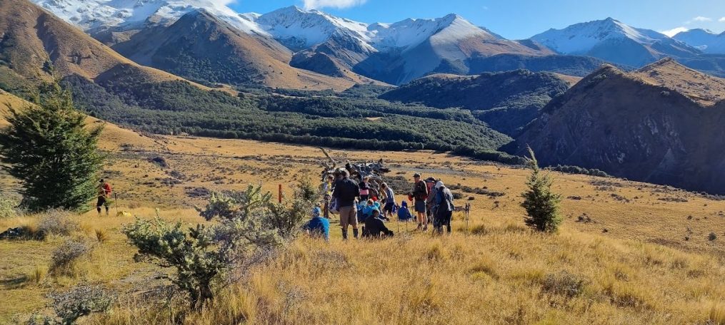
Seventeen standards headed off up Peak Hill Track initially lead by Chris, who kept us at a cracking pace until we stopped for morning tea just under the first ridge.  We gazed out at the beauty of the land below – the Braided Rakaia below us and Lake Coleridge to the left with farmland woven along the base of staunch rounded hills and peaks.

After morning tea Dave R. took over the lead as Chris was feeling a bit knackered and decided to make his way slowly back down to the bus (probably the result of that steep climb at the beginning and some new meds).  [He quite enjoyed the superb east/west views from half-way down the slope while having a very leisurely lunch, getting back to the bus not long before the Alternates. President Jan did remind him of the by-laws and the need for someone to accompany him; but he did not want to hold people up or spoil somebody else’s day.]  

Dave led us upwards over several humps, each deceivingly suggesting we were arriving at the top. Finally, a group of stones greeted us at the top.  After a photo we settled down for lunch looking up towards the mountains, some with a little snow. The sun was shining and there was a slight breeze.  What a picture-perfect view of braided rivers, humpy hills, faraway mountains of the Main Divide and green manicured valleys.  Stunning!!!

After lunch we headed over the hill and lined up with an old fence that went straight downhill towards Mt. Oakden.  Low scrub, matagouri and Spaniards mingled with gentians were scattered around us.  Alan H. (who had been trimming the lower track for the Alternates) came up to meet us and guided us to the corner where we met the track. This lower track was a mixture of bracken, muddy areas, slips, stumps and holes.  We had to watch our feet all the time.  

We arrived at the bus soon after the Alternates. A very pleasant day. 

Txt by Nicky

Tiromoana Bush Walkway-Kate Valley 2 March 2022

Group Leader Mentor Understudy Tailender
Standards Wendy A Peter Gary  Judy R
Alternates Leonie Norma Linley Maureen C

Stats: Standards: Distance 12.8km, Vertical ascent 424m, Time 4hrs 25min
  Alternatives: Distance  11.27km, Vertical ascent 434m, Time 4hrs 18min

Being the last to get on the bus, maybe arriving at 8.31am, I was immediately seconded as today’s diary writer, I think as a reaction for my lateness? Passing down the bus and looking for a safe refuge, I sat myself next to Gary and after chatting for a while he told me he was on the weather team for this outing. Looking out the bus window one could observe the precarious state of the weather with dark clouds overhead, but the call had been made for the green light to proceed with the potential promise of the weather clearing in the afternoon. A little later in our conversation Gary mentioned the possibility of rain for about an hour around lunch time and so it proved that Gary was really on-to-it.

In the interim vice president Bev took the microphone, possibly for the first time, to welcome us all, introduce our visitors, and to inform us of the 2 leadership teams, which she did, I think, with great aplomb.

The welcome at Tiromoana car park, arriving around 10am, was punctuated by a fair amount of dampness underfoot with various trampers deciding to wear their raincoats from square one but with me choosing 3 layers with my polar fleece on top. However, trampers tumbled out of the bus with their usual enthusiasm as if it was a lovely summer’s day and Wendy was the standard’s leader and after a short walk down the starting path, we were directed to pass through a deer fence gate, this built suspended into the fence and so requiring us to step through it: feet up, heads down, and backpacks off, 20 standards followed by 19 alternatives! We proceeded along a wettish grass path, the Te Ara Tawhai track, mainly descending to our tea and biscuit break at the look-out, this affording good views of the surrounding areas but being aware that our destination included the further off coastline with the need to get there but not before climbing Ella Peak. According to the map, this peak has an elevation of 346m and takes 50min return but helped by the fact that we could leave our bags to be picked up when returning down the same track.

The alternates also commenced this climb, but their leader Leonie led us to the Te Ara Kānuka track and as the name suggests it was a large stand of kānukas. The track weaved between the bush and soon we met up with the main walkway. A nice diversion from the usual track. During the walk down the road to the ford we passed a paddock of plants with a very strong smell, this turned out to be fennel and some members remarked it smelt like curry powder.

Upon returning to our discarded backpacks some decided to again put on their raincoats as rain was in the air but with me taking the gambol it would stop and so stuck with my polar fleece option. However, my unusual optimism proved to be unfounded, so after about 20min of walking in fairly light rain decided to put on my raincoat which proved just as well as Gary’s anticipated hour of rain more or less eventuated as we proceeded our descent to our coast line lunch stop when thankfully it stopped raining and we precariously seated ourselves on various log debris to eat our lunch in the presence of a cool breeze and noting that Norma in her usual organised manner was sitting comfortably under her umbrella already enjoying her picnic!

Our return via Tirimoana Track passed a conveniently situated portaloo and the nearby farm and can be described in simple terms as “uphill”! But the track took us through a lovely, forested area where we passed various fantails which entertained us with their hovering aerobatics and song.  The walk up the hill to the bus was completed without trouble, the standards uniting with alternatives, but no one was worried and just happy to be back at the bus.

For my money the weather team made the right call as we had all dried out by the time we got to the bus, roughly at 2pm. We all had a great day!

Keith L & Ray B    

Craigieburn Valley 23 February 2022


Group Leader Mentor Understudy Tailender
Stds Alan H Chris Jan Ba Margaret E
Alternates Margaret S Norma Leonie Eric

Stats: distance 14km, vertical ascent 612m, time 4hrs

As we settled into our bus ride west to Craigieburn Ski Field, President Jan welcomed the 37 members and 3 visitors (Tony, Steve and Jackie) to today’s tramp. She acknowledged the uncertainty of future bus options with Leopard coach lines in liquidation and extended our best wishes to Viktor, today’s driver. Jan also advised that the Committee was considering options with the ongoing Omicron spread and have taken the option of carrying on tramps with strict mask wearing on the bus and no refreshment stops. The Committee will respond to other options as and when required.

On a lighter note, one of our lovely members was seen just getting to Yaldhurst on time for the pick-up and had to admit to sleeping in until 8.30 am after setting her alarm for 6.30 PM not 6.30 AM as she thought! Well done for just getting there maybe with not much food on board!

On a cloudy but calm day, the 23 strong standard group were dropped off at the Broken River ski field road and were ready to depart at 10.10 am. After the arduous tramp to Mt Oxford and Ryde Falls last week the enjoyable walk up through the bush was appreciated.  We had a morning tea stop at 10.40 am perched along the bush track and then on and upwards to the base of the ski field. We carefully crossed eight scree slopes with some members not wishing to look down at the long drop. We were rewarded with  lovely views of the mountains and bush and lichen covered trees and took a lunch break at 12.45 pm.

A short walk after lunch saw us reach the base of the Craigieburn Ski Field and we wondered about the very steep tow rope which took you up the mountain. With a quick toilet stop near the lodge, we joined the ski access road back down to the bus where the alternatives were waiting for us.

Craigieburn Forest Park is a 447 square km protected area adjacent to Arthur’s Pass National Park.  DoC carries out administration for conservation and regulates commercial activity. Broken River Ski Area and Craigieburn Valley Ski Area are within the borders

Not a lot of bird song, but lovely bush, lovely mountain views and not such an arduous walk this week.  Text by Janice

The 17 Alternatives led by Margaret S were dropped off at the Craigieburn Valley carpark in overcast, damp conditions but in ideal temperatures for the walk up the valley.

After a short walk up the ski access road they veered left up the valley in the shelter of the native forest. Morning tea was had on the narrow track before continuing on. The scree slopes were negotiated safely, and several remarked they didn’t seem as difficult as last year. Above the track on one of the scree crossings was a magnificent wild Spaniard (Aciphylla colensoi) in full bloom. Not something anybody wanted to get too close to.

Lunch was had at the skifield buildings and in the distance, Standards could be seen making their way across the scree. The group then headed down the road at a fast clip and were back at the bus just after 2.00pm. A great day in the mountains. Text by Ray B

Mt Oxford-Ryde Falls 16 February 2022


Group Leader Mentor Understudy Tailender
Stds Glenys Jan Bbr Nicky Kay
Alternates Norma Wendy Kate Kiwan

Stats for the day: 13.7km, 903m elevation gain, total time 5hr 30min

Around 1880, the Ryde brothers started logging in this area.  They had 500 acres to work.  Totara, Black Beech, Matai, Kahikatea and Rimu were logged up till 1909. The timber was sold in Canterbury and used for roofing shingles, posts, rails, building timber and railway sleepers. Fire was the biggest hazard for the brothers and in 1889 fire gutted the whole valley.  The brothers were not the only ones to lose their mill.

Over 140 years later 52 trampers set off from the Coopers Creek starting point. A small confusion resulted in Glenys seeing the bus fly past her on Tram Road but a brief wait by Victor at Mandeville and we were all caught up. Jan noted that seven out of eight of the official roles were being undertaken by women.

A larger group of 31 set off to walk to Ryde Falls while an intrepid 21 opted for Mt Oxford.

A light southerly front accompanied us, making for agreeable temperatures; less enjoyable was the muddy track. Agility helped when crossing the quagmires. Before long, our leader called for a welcome morning tea stop, although we had received treats in celebration of Eric’s new OBE status. A hum of wasps was audible, and while not a significant problem, one of the alternates received a sting. Although a few were bothered by sandflies, an application of insect repellent and cooler day helped. Fortunately, there was not a plague of mice which occurs when there is a beech mast season, with an abundance of food for the birds, and too, the rodent population. (Not a pleasant experience years ago when walking with young children.)

As we moved along there was much discussion on breaks that members were proposing or had enjoyed. Milford and Queen Charlotte Tracks appear popular. Other chatter included honeymoons, stream crossing, boot cleaning, lace tying techniques, identifying clematis, horopito and rimu trees. The alternates lunched in sunshine near a hugely scoured confluence of Ryde Falls Creek/Cooper’s Creek west branch before returning along the same track. The standards were sighted from a rocky vantage point, as both groups neared the waiting bus.
Txt by Marie-Therese

Mt Oxford (Standards)
21 trampers set off to climb to the summit of Mt Oxford. After negotiating the mud in the early part of the track we started to climb and climb, with the occasional flatter spot giving short relief before heading up again. Despite the will, the constraint of time meant we stopped 170m short of the top. A rocky outcrop provided a good lunch spot with views over the Canterbury Plains. We then headed back down on the steep descent arriving back to the bus a few minutes before the Alternates arrived.
Txt by Jan Bbr

Tramping Programme 6 April 2022-29 June 2022

Note: Tramps all cost $20 – unless otherwise noted

6 April                 8.30am                Prebble Hill

Standard route: Follow farm tracks across the river and to the ridge for lunch with spectacular views of Broken River Valley. After lunch, track down and follow route over stock bridge to bus.
Alternative Route: An easy walk over farmland and stock bridge, followed by a steady climb through tussock to limestone tors. Return the same way.

Stats: distance 10.1km, ascent 298m, time 4hrs
Alternative Pickup: Yaldhurst

 13 April               **8:00**            Mt Barrosa, Stour River

Standard route: Steady climb to the top of the mountain, then return via same route.
Alternative route: 2hr up Stour River, return via same route.

Stats: distance 7.3km, ascent 824m, time 4hrs 30mins
Alternative Pickup: Yaldhurst

20 April              8:30am                Flagpole

Standard route: Undulating farm track above the Selwyn River, then a climb through pine trees and open country to the saddle for lunch. Continue up to Flagpole then down the farm road to the bus. The leader may choose the anticlockwise route.
Alternative route: Undulating farm track above the Selwyn River to lunch by the river. Return by the same route.

Stats: distance 17.6km, ascent 594m, time 4hrs 50mins
Alternative Pickup: Yaldhurst

27 April               8.30am               Camp Saddle

Standard Route: Approach via the Broken River Ski Field road, then climb to Camp Saddle. Walk along ridge then down the scree slope and return to the bus.
Alternative Route: Walk along the track to Lyndon Saddle and up Helicopter Hill. Return to the saddle then back to Broken River via the Craigieburn Track.

Stats: distance 13.4km, ascent 750m, time 4hrs 50mins
Alternative Pickup: Yaldhurst

4 May                8.30am               Hill Top to Cooptown

Standard route: Climb through native forest and a rocky gully beneath cliffs in Montgomery Reserve, then through Whatarangi & Mt Sinclair Reserves. Descend through farmland after lunch.
Alternative route: Undulating track from Pettigrews Road through Whatarangi & Mt Sinclair Reserves. Descend through farmland after lunch.

Stats: distance 15.8km, ascent 728m, time 4hrs 30mins
Alternative Pickup: Halswell

 11 May               8.30am                Mt Vulcan

Standard route: Undulating tramp over farmland and on farm tracks; steady climb to lunch stop and later on to top of Mt Vulcan. Great coastal and inland views.
Alternative route: As above but sidling around Mt Vulcan with no major climbs.

Stats: distance 12.9km, ascent 250m, time 4hrs 30mins
Alternative Pickup: Woodend

18 May               8.30am               Washpen Falls

This is a commercial operation. The committee may review the cost for this tramp at the March meeting due to the entry fee required.

Alternative Route: Climb through an ancient volcanic canyon filled with native bush and birdlife. Descend following a creek and waterfalls.
Standard Route: As above but continue to the top of the peak for lunch and wonderful views of the Canterbury Plains.

Stats: distance 15km, ascent 475m, time 4hrs 40mins
Alternative Pickup: Yaldhurst

 25 May               8.30am               Hoon Hay Reserve to Omahu Bush

An easy to moderate ridge walk with some climbs and descents. Lunch at Coopers Knob.

Standard Route: An undulating Port Hills walk along the Crater Rim Walkway, then various tracks in Omahu Bush.
Alternative Route: As above, but a shorter loop in Omahu Bush.

Stats: distance 13km, ascent 260m, time 3hrs 50mins
Alternative Pickup: PM Hospital

1 June                 8.30 am               Barnett Park to Pony Point

A mixture of gradual and steeper climbs and descents between Barnett Park and Pony Point. Both groups together from lunch.

Stats: distance 15km, ascent 568m, time 4hrs 30mins
Alternative Pickup: Windsurf Area, Humphries Drive

8 June                 8.30am               Tree Planting followed by a walk

Area to be planted is approx half a kilometre east from the junction of Mt Pleasant Rd and the Summit Rd, on the downhill side of the road.

The bus will park at the pine trees at the top of the East enders track approx 1km from the planting area. Any gear from the planting can then be put on the bus as we walk past.

We propose to walk up past the gun emplacements, probable late lunch spot. Then walk down the ridge through the Urumau Reserve to Lyttleton. Possible deviation to Timeball and or walk along main street for a takeaway coffee/ice cream etc, then to Marina for pickup.

Stats: n/a
Alternative Pickup: Windsurf Area, Humphries Drive


15 June               8.30am               Mt Alexander

Standard Route: A steady climb on farm tracks to the summit and loop track back to the bus. Wonderful views.
Alternative Route: As above to the summit but returning via the farm tracks.

Stats: distance 15km, ascent 672m, time 4hrs 45mins
Alternative Pickup: Woodend

22 June               8.30am               Leith Hill Slump – Kura Tawhiti

Both Groups: A steady climb through bush initially following logging trails, then down across the river before an uphill stretch past the sinkhole. After lunch continue on Castle Hill Station track to Kura Tawhiti.
Alternative Route: This group may elect to omit the logging trail section of the tramp.

Stats: distance 9.5/ 8.8km, vertical ascent 338m, time 4hrs
Alternative Pickup: Yaldhurst

29 June               8.30am               Mt Thomas

A steepish steady climb all the way to lunch, then downhill to the bus.

Standard route: Up Ridge Track to Hunter Hill then along the ridge to the summit of Mt Thomas, returning via the Wooded Gully Track.
Alternative route: As above with the option to go down the Wooded Gully Track or continue to Mt Thomas and return down the Summit Track (very steep).

Stats: distance 15km, vertical ascent 790m, time 5hrs 45mins
Alternative Pickup: Ohoka Rd Silverstream between Island Rd & Silverstream Blvd

The annual birthday lunch will be held on 6 July.
Details will be provided nearer the time.

Gebbies-Packhorse-Kaituna 9 February 2022

Group Leader Mentor Understudy Tailender
Stds Warren Chris Shirley Margaret E
Alternates Leonie Norma Margaret S Bruce

Stats: distance 13km, ascent 560m, time 4hrs 40mins

We set off from Bishopdale with Viktor as our bus driver. It was a dull grey day and the forecast was for rain to arrive about 4pm. Once we had stopped at Halswell to pick up the rest of our trampers, we had a total of 44 enthusiastic trampers including five visitors.  Jan our President passed a bag of goodies around the bus as it was her birthday (and her partner Alan’s the week before!).  This was much appreciated by all.

The bus travelled through Tai Tapu and round the hills arriving at the top of Gebbies Pass at 9.30am.  Departing the bus, we were met with a cold wind and more grey skies.  With 22 trampers in each of the Standard and Alternate groups, we set off with the Standards leading off first on the forest track.

The landscape was rather desolate for the first part of the tramp as with the cloud cover there were no amazing views to take one’s eyes off the felled pine plantation debris which seemed to stretch over much of the hillsides. We did get glimpses of Lake Ellesmere and Lyttelton Harbour when the low-lying cloud temporarily cleared. All the logging had changed the landscape so much that the Alternates took a wrong turn at a forest track crossroads and had to walk quite an extra distance to get back on the right track once they realised.  Once off the forest tracks, we followed a fairly narrow, well-worn track which meandered through tall pine forest, grassy hillsides and pockets of native bush.  We stopped for morning tea at about 10.15am on a grassy hillside.

Continuing on, our Leader Warren paused beneath what is known as the Remarkable Dykes. These are a pair of rock walls that form the boundaries of a crack in the side of the Lyttelton Volcano. We noted it would not be a good place to be beneath in the event of an earthquake as the rocks looked rather large, weathered and crumbly in places. We carried on to the Packhorse Hut which was built in 1916 by Harry Ell as one of four rest houses for a proposed route from Christchurch to Akaroa.  The Hut sits on a low open saddle between Mt Bradley and the Remarkable Dykes.

From the Packhorse Hut we followed the track through the beautiful Packhorse Hut Reserve, noting the amazing lancewoods in particular, coming out into the open to the zig zag track which makes its way up the base of Mt Bradley. We made our way up the zig zag still surrounded by low cloud and at 12 noon on the dot we found a spot in the tussocks to have our lunch.  If we had wanted to climb to the top of Mt Bradley it would have taken at least another two hours to go up and down from where we stopped for lunch so that was not an option due to time constraints. It would also be a lot of effort for no view at the top due to the cloud cover.

At 12.20 pm we started back down the track the way we had come up, arriving back at the Packhorse Hut where we met up with the Alternates who were having their lunch there.  We could see down into Kaituna Valley where the bus was waiting for us in the distance. Climbing a style, we headed down the hill following a farm track through the trees arriving at the bus at 2pm.  The Alternates joined us, and the bus set off for home at 2.30pm.

Although we missed out on what would have been wonderful views on a sunny day, it was still a great day out on an excellent track, and we were lucky that the rain held off until we were back in Christchurch. Txt by Judy R

Glenafric 2 February 2022

Group Leader Mentor Understudy Tailender
Stds Selwyn Chris Kaye Bev
Alternates Ray Norma Margaret S Linley T

Stats: distance 14.3km (alternates 13km), vertical ascent 640m, time 5hrs

With the threat of rain, it seemed like the Glenafric Tramp may not go ahead, but we woke to a dry, mild overcast morning and – no emails.

Scattered showers were forecast for later on in the afternoon, but that wasn’t enough to put off 46 Trampers including four visitors.  With our driver Alan we set off North to Waipara Junction where we would turn off to Glenafric farm, a coastal beef and sheep property the owners kindly let us tramp over.

The groups split in to two when we arrived, and both leaders were given written instructions for the route, quite important on this tramp since there had been previous indecision about the direction to take. There was no problem with the first uphill, apart from it being reasonably steep, and we soon made it to the top for morning tea overlooking the farm.

The tramp continued across farm paddocks to a fence line on the hillside. As always there was a discussion about the best place to clamber through. After first making sure the electric wire was off, the usual solution was adopted. Some went lower down the slope, some higher up and some stayed in the middle. At this stage the alternatives could be seen walking higher up on the hill above the fence line – had they found a better option?

The fence safely negotiated we regrouped and carried on over undulating farmland before dropping down to a valley, and the first of the river crossings.  There had been the odd spattering of rain, but when it started getting heavier, with mutterings of “this is earlier than they said”, some decided it was time to put on wet weather gear, despite it being mild and muggy.  Fortunately, it was just a short shower, and the wet weather gear, still reasonably dry was packed away.  There was no problem staying dry with the numerous stream crossings either. With plenty of stepping stones and the odd helping hand there were no major mishaps.

Leaving the stream we climbed to our lunch spot on the cliff top with spectacular views overlooking the ocean, and Motanau Island to the North. With little wind, it would have been the perfect spot if not for the flies. There was plenty of Aussie waving going on, and a corked hat was mentioned as being a possible solution.

After lunch the tramp crossed more paddocks, with some curious cows in one, before dropping down closer to the coast, where we wended our way through long grass, thistles – and seeds. At this stage it helped to be nearer the back, as the front trampers flattened the grass making it easier for those following. Once away from the grass the landscape changed to dry uneven lumpy ground with rutted tracks, the result of movement associated with plate tectonics. This eventually led to the track down to the beach.  It was all eyes down on the stony beach, not just for scrambling over the stones, but also to keep an eye out for fossils, which the beach is known for, and some trampers had found previously.

On the last slog uphill, after crossing Dovetail stream, the alternatives could be seen on the opposite hill making their way down the farm road toward the beach. They would bypass the beach though and join the steep uphill track before crossing by the homestead and along the road to the bus. Back at the bus the standards had time to remove some of the stubborn seeds from socks and boots. We even got to see the farmer and some of his flock as he passed by.

Although over farmland, the tramp proved to be quite challenging, but with plenty of variety and some great views, so another enjoyable day out.  Txt by Sally

Okuti Valley 26 January 2022


Group Leader Mentor Understudy Tail Ender
Standards Dave R Alan H Gary Sally
Alternates Norma Jan Bbr Margaret S Pauline

Stats: distance 14.8km, ascent 720m, time 4hrs 30mins

With Viktor driving there were 48 trampers and 5 visitors: Steve Gray, Hetty Syme, Jaki Horn, Daphne Hazelgrove and Pip Lynn. It was a mizzly sort of morning as we boarded the bus – brightened by masks of various hues and sorts worn as required in Covid’s current red light setting.  The day brightened a little on our way to a new tramp on Banks Peninsula’s volcanic hills.

The first people to settle in this area around 1300AD were descendants of explorer Rākaihautū, founding ancestor of the Waitaha. The story is told that following his arrival in Whakatū, Nelson with his kō or digging stick, Rākaihautū travelled south, digging out the lakes and rivers of Te Waipounamu. Among these are the lakes we drove by:  Te Waihora, Lake Ellesmere and Wairewa, Lake Forsyth. Each lake has a story which is part of a larger narrative. Te Waihora is called Te Keteika-a-Rākaihautū (Rākaihautū’s fishing basket).

We had a comfort stop at Little River’s railway station (the terminus of a branch railway from 1886 until 1962). Apparently Little River was also a coaching stop on the way to Akaroa, and developed as a sawmilling settlement, supplying timber to Christchurch.

On the Okuti Valley Road, past the Little River Campground our walk started with a gentle climb through the Okuti Valley Scenic Reserve. This is a remnant of lowland forest with kahikatea, tōtara, māhoe and kānuka. And we spotted a box for ruru.

Most of the walk was through farmland. Invigorating walking. Outwards to French Peak and returning the same way. While the cloud looked as though it might lift, it didn’t and so the Standard group didn’t reach French Peak, instead stopping and lunching below with pine trees and cows for company. The conversation was as ever an enjoyable part of the walk.  In light of recent Omicron related media stories and the suggestion that people over 6o stay home and lock down what might be the response if we got lost in the mist? And quite unrelated, a hot tip for an unexpectedly good tipple from Charteris Bay – Whistling Buoy 2016 Pinot Noir.

The return walk was mostly downhill, and we were back at the bus early enough for there to be a chunk of the afternoon remaining when we got home. It was a good refreshing day out despite the clouds and missing out on the French Peak views. Thank you to all for making it so.

Coalpit Spur 19 January 2022

Leader Mentor Understudy Tail Ender
Standards Alan H Dave R Gary G Judy R
Alternates Norma P Lynne R Nick A Bill W

 Standards: Distance: 11.3km Duration: 4hrs Elevation Gain: 565m

Alternatives: Distance: 10.5km Duration: 4hrs 10min Elevation Gain: 394m

Coal Spit Spur Track is a new tramp on our BTC calendar but we were aware of the forecast threat of a heatwave followed by afternoon rain, which fortunately in the Craigieburn Forest area did not eventuate.  Instead we enjoyed close to perfect weather conditions for this new venture. Our full bus encountered a number of traffic stops, this somewhat delaying our tramp to a later start.

Upon our arrival all were delighted to be greeted by a lovely beach forest commencing with Mistletoe track, this providing tree canopy sheltered tramping, starting on a slight upward slope enabling trampers to gain their second breath before taking a short tea and biscuit break.  We recommenced on a now significantly steeper ascent until arriving at the foot of Helicopter Hill. Here the Standards were given the option of dumping their backpacks and climbing this hill to take in the magnificent vistas offered by this 15-to-20-minute climb. This excursion was bypassed by the Alternatives but otherwise both groups followed the same route.  Helicopter Hill has an elevation of 1256m and concluded the main climb of the day. 

After grabbing our backpacks, we headed down the Luge track amongst more open bush, which took us to a hairpin bend that pointed us in the direction of the Coal Spit Spur Track. We continued on seeking a suitable place for lunch, which we eventually found on the left of the track revealing a beautiful steep sided valley slightly hidden by scrub and bush, which we passed through to expose this magnificent vista and picnic spot. After lunch we continued mainly on a downward descent eventually catching up with the Alternative tail enders and having to cross a number of not insignificant rivers and streams, this helping to ensure that my boots were as clean as they had been for some considerable time! As usual, towards the end of our tramp, our expectation of finding the bus around the next corner proved to be illusory as some further track ascent was needed before concluding our tramp. One has to concede that the removal of one’s boots upon arrival at the always welcoming sight of Leopard bus is a highlight of a day’s tramping, this additionally providing us all with some sense of achievement and wellbeing. It was decided not to stop on our long journey home partly because of our late start and similarly delayed journey home because of various traffic events. 

I need to acknowledge Kate’s indirect input to this story by providing pen and paper and a number of pics mainly taken on Helicopter Hill.

Text by Keith L