Christmas Walk and Lunch 11 December 2024

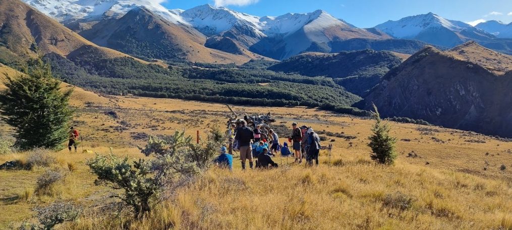
This venue for this year’s Christmas tramp and lunch was not only new but close to home: the Adventure Park is tucked into the Cashmere Hills and has seen two major fires in the last five years. Your scribe had been warned that it was a major climb but, after Mt Thomas last week, today was just a walk in the park. The plan was for Standards was simple: climb to the top of the hill and get the free chairlift ride down. There were plenty of scorched trees; some had been severely burned at the bottom but showed no ill effects at the top. The main hazard was boys travelling at speed downhill on tracks that crossed the trampers’ track. Meanwhile the Alternatives were walking around the bunding area in the valley below yet another subdivision on the hills.

The main event was lunch and meeting several members who were either Associates or had not tramped for some time. It was certainly a joyous occasion and an excellent end to another year of tramping and companionship.

Text by Peter M

A Christmas Jollity

‘Twas two weeks before Christmas
And all through the city
To miss out on a walk
Would be such a pity

The packs were stuffed full
Trampers raring to go
To climb up the hill, (most with a will)
Though some were slightly more slow

Nineteen Standards set off in the sunshine
Thirteen Alternates at a more leisurely pace
From the Adventure Park they did wander
It was certainly not much of a race

No summer’s nap for any of us
Christmas lunch was primarily the goal
There’s much of a clatter, and many a chatter
Bishopdale Trampers always ready to roll

Nor for us, a miniature sleigh.
With a smile and a twinkle in eye
On Wednesdays we’re off and away
(Most all of us lively and spry)

President Jen always calls us by name
Not Dasher or Dancer or Donner or Blitzen
She’s done well through the year
Not a name has she managed to mix’n!

No smoke on the hills in the area
In February things were unfortunately ablaze
Alternates passed by the cool of the water
Stopped by the Old Stone House for a graze

Standards meantime had their eye on the top
Hoping the gondola would indeed be a’go
If non-operational, oh dear
Downward walk would be a positive blow

The trampers all arrived safely back
More troops waited to join in the fun
Like St Nick with his crammed sack
All enjoyed their Christmas lunch in the sun

We’ve had such a good time through the year
Great tramps, companions and laughter
2025 should be good!
Looking forward to the walks hereafter!

Feliz Navidad!

Text by Marie-Therese (with apologies to, and drawing on the writing of, Clement Clarke Moore)

Tramping Programme 15 January 2025 – 26 March 2025

TEN TRAMP MEMBERSHIP QUALIFICATION YEAR: 1 April 2024 – 31 March 2025

The cost of all tramps is $25 unless otherwise noted. 

15 January          8.30am              Rakaia Gorge Walkway

P/U: Yaldhurst

Standard route: An easy walk from Evans Family Reserve to the boat harbour and return.  Some moderate climbs and descents with lovely river and gorge views.

Alternative route: As above, but via the LoopTrack

Stats: distance 10.3km, vertical ascent 414m, time 3hrs 30mins

22 January          8.30am              Hoon Hay Reserve to Sign of the Bellbird

P/U: PM Hospital

An easy to moderate ridge walk with some climbs and descents.
Standard Route: An undulating Port Hills walk along the Crater Rim Walkway to Gibralter rock then back to the Bellbird.
Alternative Route: As above to Coopers knob then back to the Bellbird.
Stats: distance 13km, ascent 260m, time 3hrs 50mins

29 January          8:00am              Mt Alford                            NB: EARLY START                                            

P/U Yaldhurst

Standard Route: Steady climb through Alford Reserve beech forest, tussock country and then sub-alpine scrub to top of Mt Alford. Great views. Return via same route.

Alternative Route: Same as above climbing as high as able.

Stats: distance 9km, vertical ascent 730m, time 4hrs 45mins

5 February           8.30 am           Barnett Park to Pony Point         

P/U: Barnett Park

A mixture of gradual and steeper climbs and descents between Barnett Park and Pony Point.

Alternates: different track to Standards before lunch.

Stats: distance 15km, ascent 568m, time 4hrs 30mins      

12 February        8.30am              Hogsback Track – Castle Hill                    

P/U: Yaldhurst

Standard route: Tramp along an undulating mountain bike track from Castle Hill Village to the western end of Hogsback Ridge.  After lunch on the ridge and return along the same track.

Alternative route: As above but stopping for lunch along the track as suits.

Stats: distance and ascent yet to be recorded, time 5hrs

 19 February      8.00am              Mt Richardson                                 NB: EARLY START

P/U: Ohoka Road Silverstream by Hayson Dr

Standard Route: Climb Mt Richardson track to the trig station at the summit, then continue east along Blowhard Track and down the Bypass track.

Alternative Route: Ascend Mt Richardson track as far as is comfortable and return via the same route.

Stats: distance 12.4km, 660m, time 5hrs  

26 February        8.30am              Sign of the Bellbird to Evans Pass

P/U: N/A

An open, grassy ridge climb with some rock-hopping to start and then ranging from easy to steeper climbing and descent sections.

Standard route:    Crater Rim walkway from the Sign of the Bellbird to Evans Pass.

Alternative route: Crater Rim walkway from the Sign of the Kiwi to Evans Pass.

Stats: distance 17km, vertical ascent 410m, time 5hrs

5 March               8.30am              Boundary Hill – Red Lakes

P/U: Yaldhurst

Standard route: Grassy river terraces and alpine pasture with a climb to the top of Boundary Hill for outstanding 360 degree views.  An initial steep descent, then a four-wheel drive track to the Red Lakes and Lyndon Rd.

Alternative route: The route forged follows a four-wheel drive track up the valley before the fault line, to Boundary Hill. Those who wish to, can climb to the summit for lunch. All return via the fault line.

Stats: distance 11.5/7.6km, ascent 519m, time 4hrs.

12 March             8.30am              Hill Top to Cooptown

P/U: Halswell

Standard route: Climb through native forest and a rocky gully beneath cliffs in Montgomery Reserve, then through Whatarangi & Mt Sinclair Reserves.  Descend through farmland after lunch.

Alternative route:  Undulating track from Pettigrews Road through Whatarangi & Mt Sinclair Reserves.  Descend through farmland after lunch.

Stats: distance 15.8km, ascent 504m, time 4hrs 30mins

19 March             8.30am              Lake Rubicon                     Note: additional $10 entrance fee

P/U Yaldhurst

Standard route: Farm walk with an initial climb, then undulating before a short steep climb to lunch overlooking the lake. Descend, then return via the Rubicon River flats.

Alternative route: As above but shorter route to the lake.

Stats: 400m, distance 13.7km (Alternates 11.8km), ascent 400m, time 4hrs 50mins

26 March             8.30am              Leith Hill Slump – Kura Tawhiti

P/U: Yaldhurst

Both Groups: A steady climb through bush initially following logging trails, then down across the river before an uphill stretch past the sinkhole. After lunch continue on Castle Hill Station track to Kura Tawhiti.

Alternative Route: This group may elect to omit the logging trail section of the tramp.

Stats: distance 9.5/ 8.8km, vertical ascent 338m, time 4hrs

Mount Thomas 4 December 2024

Group Leader Mentor Tailender
Standards Selwyn Alan H Veronica
Alternates Moira Les Joanne

Stats: Distance 11.76km    Ascent 790m    Time 4hrs 55 mins

Mt Thomas is known as one of our more strenuous walks which could have been a factor in just 31 members signing up for the excursion. It was good to see a group of 23 opting to walk with the Standards. Today we had three visitors helping to make up our numbers.

The last three tramps on Mt Thomas have been during the winter months, offering the possibility that this is to increase the chances of it being cancelled due to bad weather, or simply to make the steep climb more tolerable at a cooler time of the year. Whatever the reason for the scheduling, the reality is that it is quite a few years since we have “knocked the B…… off” and there were high hopes that today would be the day!

We got away from Bishopdale on time with a pleasantly uneventful bus trip with two stops, one to pick up Bev, and a comfort stop at Loburn Reserve. The forecast for the day was 24 degrees with high humidity and very little wind.

The usual route of up the Ridge Track and down the Wooded Gully Track was unavailable as the latter was closed due to a slip. The proposed longer route included going up the Summit Track to the top of Mt Thomas and continuing along the ridge on the imaginatively named Ridge Track all the way to the start point at the Wooded Gully Camping Area.

President Jen warned us on the bus that the tramp would be longer than usual for the Standards if they completed the loop.  Our leader Selwyn explained at the beginning of the tramp that we would ascend the Summit Track and possibly return the same way if it looked like we wouldn’t have time to complete the full loop.

It appeared that Selwyn was fairly keen for us to complete the loop on ‘his watch’ and set off at a very steady (unrelenting) pace. One of our group was not feeling 100% and returned with one other about three quarters of the way up. The temperature, humidity and pace got us feeling very sweaty and keen to be consuming water. Most people carried extra water which proved to be a good call.

We started walking around 9:50am and reached the top at 11.45am. We stopped for the obligatory summit photo and a few minutes of rest, called “admiring the view”.  Reaching the summit before midday was a great effort. We continued along the Ridge Track until we came to the Wooded Valley Track junction at 12:25pm and stopped there for lunch in a nicely shaded area complete with bellbird song. As this was roughly halfway, and barring a mishap, we were confident of completing the loop.

We continued upwards on the Ridge Track until it headed south and downhill.  Shortly after the turn we came across the Alternates who I’d have to say were looking quite fresh and relaxed. Care was needed on the steep descent and our admiration for the Alternates, who had ascended via this route, increased markedly. We arrived back at the bus around 2:45pm with the Alternates a few minutes behind. The total time of less than 5 hours was a great effort and less than the advertised 5 hrs and 25 mins. A number of trampers had never reached the summit of Mt Thomas so there was a general feeling of satisfaction in having conquered it at last.

On reflection, it was a strenuous day, particularly in the warm, humid conditions, and a great effort by all 31 of us. Thanks again to Peter for driving us home safely and for getting Dave back in time to weigh anchor at Lyttelton.

Text by Steve Bw

Awa Awa McLellan’s Bush 6 November 2024

Group Leader Mentor Tailender
Standards  Peter M Lynn B Frank
Alternates  Michele Ali Tessa

Distance 11km, ascent 640m, time 4hrs 45mins.

There were 32 of us on the bus as we headed away in the direction of the Southern Alps. Included in our number were our welcome repeat visitors, Andrea and Jenny, as well as our returning Himalayan tramping greats, Jan Bb and Alan H.

Our drive to McLennans Bush Road was so unremarkable that one of the highlights, other than Viktor’s superb driving skills of course, was the nice new toilet block in Hororata. Further on, even better was the incredible panoramic view down to the Rakaia bridge and across to the simply breathtaking vista of the cloud-shrouded Alps.

Also impressive were the rhododendrons which are a glorious feature of the Awa Awa Reserve. Apparently the first of the 700 or so were planted in 1968 and some hard-working volunteers are still planting more. There was even a cute new toilet building (one wonders if all these new toilet blocks have been built solely for our ‘convenience’?).

Although using AI to aid in the writing of trip reports is not encouraged, let’s assume there’s nothing wrong with stealing other people’s work. Chris S, past report writer extraordinaire wrote so eloquently in 2018:

As we sauntered through the vibrant rhododendron blooms, our two usual groups formed and at the start of the Scott’s Saddle Track the Standards took the lead. Under foot was a little squishy from recent rainfall, and the tangled tree roots made careful negotiation essential as we proceeded to climb through predominately mature beech/tawhairauriki forest dotted with occasional southern rata. Tentative rays of sun filtering through the foliage were enough to generate that characteristic mossy fug you get from tramping in damp bush. Momentary glimpses of the Plains were visible through gaps in the beech.

More prosaic was Michele’s comment: ‘the first bit was pretty ugly, eh’ which is a great summary of the track. As well as being rather steep, it is also muddy, slippery and hazardous. Some of the 18 Standards may have smugly assumed this tramp would be easy after the trials of Mt Oxford last week. Not so. On the positive side, the weather was superb.

Morning tea for both groups was at the junction of the Scotts and the Ridge tracks. Leader Peter tried to convince the more naïve that the track would become easier from that point. Again, no. However, the landscape and flora did actually change; we tramped through a miniature forest of stunted beech trees, out to an open area of alpine plants, and then on to some screes which were fun to negotiate.

The Alts enjoyed their lunch at the bench seat lookout before retracing their steps down to the track junction, then following the Ridge Track and on to the Opuke Track down to the bus. The Standards headed on further before finding a great spot for lunch, with tantalising views of a moody Mt Hutt enveloped in cloud, before heading back down hot on the tails of the Alts.

Melodious bird song was occasionally heard as we headed downhill. Also overheard: “There’s a lot of dead wood up ahead” which may have hurt the feelings of the two trampers in front of the speaker. Also: a conversation overheard by an Alt: “Is that an aircraft down below?”   “No. It’s the Canterbury Planes!”

Some of us height-challenged hikers could occasionally be overheard commenting on how tough some of the rock and root ‘steps’ were for our short little legs. That was until we came across a charming little chihuahua happily tackling the same track. We had also encountered another striking dog along the way, a magnificent Border Collie that looked like he may have had some English Sheep dog in his blood line.

Everyone was proud of themselves for eventually making it down safely, though there were a few muddy bottoms suggesting it hadn’t always been easy.  Admiring the rhodos, and possibly the nice new toilets, was a bus load of friendly out-and-abouters, including two previous Bishopdale Trampers.

The Alts had made it back to our bus only minutes before the Standards, and were just in time to witness the drama of a campervan scraping the backing mirror of the very flash bus the rhodo appreciation group had arrived in.

The trip back to Christchurch was rather quiet, which may have been a consequence of the temperature in the bus being overly warm, or just possibly because of our big efforts. The best thing was that we had had such a busy day there had been little opportunity to ponder the dire events which may or may not have been unfolding in the US elections.


Text by Shirls

Tramping Programme 02 October 2024 – 11 December 2024

TEN TRAMP MEMBERSHIP QUALIFICATION YEAR: 1 April 2024 – 31 March 2025

The cost of all tramps is $25.


02 October         8.30am                 Halswell Quarry – Kennedys Bush – Signs of the Bellbird and Takahe

P/U: PM Hospital

A long steady climb via the quarry and Kennedy’s Bush Track to the Summit Road. Follow the track through Kennedys Bush to the Sign of the Bellbird. Cross the Summit Road and take Ellas track to the Sign of the Kiwi.

Standard route:  As above but from the Kiwi descend to The Sign of the Takahe via the Harry Ell Track.

Stats: distance 14.5km, ascent 462m, time 4hrs 30mins


09 October         8.30am                Mt Grey – Ashley Forest

P/U: Woodend

Standard route: Walk down the road to the river before a steady climb to the Mt Grey trig walk up the Mt Grey track but descend/ return by the Lake Janet track/aka Old Fire Lookout Track.

Alternative route: Steady climb from Lake Janet, returning via the same track.

Stats: distance 16.2/9km, ascent 776/507m, time 4hrs


16 October         8:30am                 Morgans Valley to Sumner/Lyttelton

P/U: None tho can leave cars at D/O where bus will return           

Standard route:  A Port Hills walk with steady climbs and descents from Morgans Valley to Evans Pass and Sumner via Urumau Reserve.

Alternative route: A shorter route also starting from Morgans Valley, looping around Urumau Reserve and finishing at Lyttelton.

Stats: not recorded.


23 October         8.30am                  Dracophyllum Flat           NB Late return – 5.00pm

P/U: Yaldhurst

Standard route: Tramp through beech forest and alpine pasture following the cycle trail almost to Texas flat, then across country via a crossing of Broken River to Hwy 73.

Alternative route: Follow cycle trail to Texas Flat, then via the Cheeseman Ski Club access road to the Broken River Bridge on Hwy 73.

Stats: distance 13.6/12km, ascent 510m, time 4hrs 30mins


30 October         **8.00am**       Mt Oxford – Ryde Falls                  NB Late return – 5.30pm

P/U: Manderville, on Tram Rd just past shopping centre and intersection

Standard route:  Mt Oxford: A challenging climb of Mt Oxford with magnificent 360-degree views to enjoy at lunch time.

Alternative route: Ryde Falls.  Beautiful steady, mostly bush walk to the falls. Some stiff climbs and descents.

Stats: distance 15km, ascent 960/218m, time 5hrs


06 November    8.30am                 Awa Awa / McLennans Bush      NB Late return – 5.30pm

P/U: Yaldhurst

Rhododendron plantings and Rata reserve.

Standard Route: Steady climb through bush up Scott’s Saddle Track to the ridgeline and lunch overlooking the Mt Hutt access road. Return via Scott’s Saddle, Ridge and Alder Tracks.

Alternative Route:  Steady climb through bush up Scott’s Saddle Track to the first sub-alpine clearing for lunch overlooking the Canterbury Plains. Return via Scott’s Saddle, Ridge and Alder tracks.

Stats: distance 11km, ascent 740m, time 4hrs 45mins


 13 November   8.30am                 Peak Hill Lake Lake Coleridge    NB Late return – 5.00pm

P/U Yaldhurst

Standard Route: Follow track from the bottom of Peak Hill to the summit, a climb of 700 metres. The leader may choose to return by the same or the alternative route.

Alternative Route: A shorter climb from the bottom to the first knob for lunch and return.

Stats: distance 9.5km, ascent 650m, time 4hrs 20mins


20 November    8.30am                  McCormacks Bay – Evans Pass – Moncks Bay

P/U: McCormacks Reserve, McCormacks Bay Rd

Standard Route: Port Hills walk from McCormacks Bay to John Britten Reserve, and Eastenders Track to Evans Pass. Then various tracks and roads to Clifton Hill to Moncks Bay. Alternative Route: As above but starting at John Britten Reserve.

Stats: distance 14.3km, vertical ascent 630m, time 5hrs 20mins


27 November    8.30am                 Mt Vulcan

P/U: Woodend

Standard route: Undulating tramp over farm land and on farm tracks; steady climb to lunch stop and later on to top of Mt Vulcan. Great coastal and inland views.

Alternative route: As above, but sidling around Mt Vulcan with no major climbs.

Stats:  distance 14km, ascent 609m, time 5hrs


04 December    8.30am                 Mt Thomas         NB Late return – 5.30pm

P/U: Ohoka Rd Silverstream between Island Rd & Silverstream Blvd

A steepish steady climb all the way to lunch, then downhill to the bus.

Standard route: Up Ridge Track to Hunter Hill then along the ridge to the summit of Mt Thomas, returning via the Wooded Gully Track

Alternative route: As above with the option to go down the Wooded Gully Track or continue to Mt Thomas and return down the Summit Track (very steep).

Stats: distance 15km, vertical ascent 790m, time 5hrs 45mins


11 December                     Christmas Walk and Lunch

Chch Adventure Park rest still to be confirmed


Tramping Programme 03 July – 25 September 2024

TEN TRAMP MEMBERSHIP QUALIFICATION YEAR: 1 April 2024 – 31 March 2025

The cost of tramps is $25

 03 July                  8.30am                  Bridle Path – Lyttelton – Pony Point – Stan Helms

 P/U: Bridle Path track, Heathcote

Steady climb over Bridle Path then undulating to Pony Point. Back to Lyttelton where the Standards continue on up Stan Helms to the Bridle Path and back to Heathcote.

Stats: distance 13km, ascent not recorded, time 4hrs

 10 July                  The annual birthday lunch. Details in the booking system.

 17 July                  8.30am             Mt Alexander NOTE CHANGED FROM Weka Pass Farm

P/U: Woodend

Standard Route: A steady climb on farm tracks to the summit and loop track back to the bus. Wonderful views.

Alternative Route: As above to the summit but returning via the farm tracks.

Stats: distance 15km, ascent 672m, time 4hrs 45mins

 24 July                 8.30am                 Dalethorpe to Annavale

P/U: Yaldhurst

Both groups:  A steady climb on farm tracks to a wonderful viewpoint on the Russell Range for lunch. Descend to Annavale airstrip alongside SH 73.

Stats: distance 14.1km, ascent 383m, time 4hrs 15mins

31 July                  8.30am                 Flock Hill

P/U: Yaldhurst

Farm Track to limestone outcrop area and over Flock Hill, returning via a second farm track.

Stats: not yet recorded

07 August           8.30am                  Sumner – Godley Head – Evans Pass

P/U and meeting point: Clocktower Scarborough.

Alternates taken to Evans Pass.

Standard route: Walk over Scarborough to Taylors Mistake, Boulder Bay, Godley Head and out to Evans Pass.

Alternative route: Walk reverse of Standards from Evans Pass  to Scarborough. There is only one major climb from Taylors Mistake over Scarborough Hill though can take a shortcut down the Annaconda track from Breeze Col or go all the way to Godley Head and around.

Stats: distance 14km, ascent not recorded, time 4hrs 20mins

14 August           8.30am                  Coalgate Forest

P/U: Yaldhurst

A farm walk with short climbs and rolling hills with great views from the Alps to the Peninsula. Return on farm tracks and Whitecliffs Rd to Farr St.

Stats: distance 12.5/ 8km, ascent 250m, time 4hrs

21 August           8.30am                  Kate Valley – Tiromoana Bush Walkway

P/U: Woodend

Standard route:  An undulating descent through Tiromoana wetlands and farmland. Detour from the wetlands track to climb Ella Peak before continuing to the beautiful Pegasus Bay beach for lunch. Steady ascent along a shingle road to the bus.

Alternative route:  As above, except for the climb to Ella Peak.

Stats: distance 12.8km (alternates 11km), vertical ascent 424m, time 4hrs 25min

28 August            8.30am                 Little River – Birdlings Flat

P/U: Halswell    

A road walk with steady climb to the ridge, along Bossu Rd and down to Birdlings Flat.

Alternative option: As above but starting at the top of Kinloch Road.

Stats: distance 17.7km, ascent 600m, time 4hrs 20mins

04 September   8.30am                 Rabbit Hill – Trig M Hill

P/U: Yaldhurst

High-country tussock foothills walk.

Stats: distance 8.6/10km, ascent 1105m, time 3hrs 45mins

11 September   8.30am                 Huntsbury – Mt Vernon Park

P/U: PM Hospital

Standard route: From the top of Huntsbury Avenue, follow various tracks to Sign of the Kiwi, Sugarloaf and Mt Vernon, eventually descending via Mt Vernon Farm Park and Bowenvale.

Alternate route: As above but not over Mt Vernon.

Stats: distance 12.8km, ascent 500m, time 4hrs 15mins

18 September   8.30am                 Charteris Bay – Purau – Diamond Harbour

P/U: Halswell

Some short steep climbs on inland rural and urban roads to Purau. with the return to Diamond Harbour along the undulating coastal margin walking track. Standards continue on the coastal path to Charteris Bay pick-up.

Stats: distance 14/9km, ascent 153m, time 4hrs 30mins

25  September  8.30am                 Washpen Falls

P/U: Yaldhurst

This is a commercial operation where there is an entrance fee that may be paid by the club. Climb through an ancient volcanic canyon filled with native bush and birdlife. Descend following a creek and waterfalls.

Standard Route: As Alternates above though continue to the top of the peak for lunch and wonderful views of the Canterbury Plains.

Stats: distance 15km, ascent 654m, time 4hrs 30min

Coal Pit Spur 27 March 2024

Leader Mentor Understudy Tail Ender
Standards Warren Chris S Jen C Judy R
Alternates Tessa Norma Pip L Maureen C

Distance: 12.6km                   Elevation gain: 772m (inc Helicopter Hill)             Total time: 4hrs 20mins

With the promise of clear(ish) skies and mild temperatures, 39 trampers including visitors Nicky C and first-timer Glen T, eagerly embarked on a day promising adventure, camaraderie, and stunning landscapes. Birthday chocolates and lollies were passed around the bus. Thank you Bernice. And thank you to our driver Garth.

The Standards, comprised of 23 intrepid adventurers, charted a course up the Luge Track, aiming to reach the ridge before descending to Flock Hill Station. Luge Track proved to be a rewarding ascent, with sweeping views of the surrounding mountains reminding us of the breath-taking beauty of the Canterbury high country.

The allure of Helicopter Hill proved irresistible to many of the Standards who opted to add an extra 30 minutes (in total) to their journey to conquer this imposing peak. A few felt some trepidation on seeing to the north the scree face descent of the upcoming Camp Saddle tramp. The river crossing on the return to the bus was described by a couple of people as “very refreshing”. (Others may have described it as cold and wet!)

Meanwhile, the Alternates consisting of 16 trampers, embarked on a shorter route starting from the drop off at the Broken River access road and looping around Coal Pit Spur before returning to the bus. The Alternates were treated to stunning views, native forest, and fabulous birdsong. In the course of their walk, trampers picked up rubbish left by prior careless visitors. Items such as broken glass, lubricant tubes, coffee cups and McDonald’s wrappers were brought out to maintain the integrity of what should be a pristine area.

It was another day of free flowing conversation as people shared tales of past adventures, current activities and challenges. As they made their way back to Christchurch, the trampers reflected on the day’s adventures with fondness, grateful for the opportunity to connect with nature and with one another. Text By Brent M

Tramping Programme 03 April – 26 June 2024

TEN TRAMP MEMBERSHIP QUALIFICATION YEAR: 1 April 2024 – 31 March 2025

The cost of tramps is $25

03 April             8.30am                  Bellbird Loop

                                P/U: PMH

A walk through Kennedys Reserve and then tracks above Governors Bay.

Stats: distance 9km, ascent 480m, time 4hrs


10 April                8.30am                 Monument – Mt Herbert – Diamond Harbour Domain

P/U: Halswell

A steady climb to the summit of Mt Herbert with some sections of the track being steep and quite long. A long descent to Diamond Harbour township and the Memorial Gardens.

Stats: distance 14.5km, ascent 552m, time 4hrs 30mins


17 April                8:30am                  Flagpole

P/U: Yaldhurst

Standard route: Undulating farm track above the Selwyn River, then a climb through pine trees and open country to the saddle for lunch. Continue up to Flagpole then down the farm road to the bus. The leader may choose the anticlockwise route.

Alternative route: Undulating farm track above the Selwyn River to lunch by the river. Return by the same route.

Stats: distance 17.6km, ascent 827m, time 5hrs


24 April                8.30am                Glenafric

P/U: Woodend

Walking over undulating farmland to the coastal cliff for lunch with great sea views.

Stats: distance 14.3/13km), vertical ascent 640m, time 5hrs


01 May                 8.30am                 Mt Alexander    NB Late return – 5:00pm

P/U: Woodend

Standard Route: A steady climb on farm tracks to the summit and loop track back to the bus. Wonderful views.

Alternative Route: As above to the summit but returning via the farm tracks.

Stats: distance 15km, ascent 672m, time 4hrs 45mins


08 May                8.30am                  Camp Saddle     NB Late return – 5.00pm

P/U: Yaldhurst

Standard Route: Approach via the Broken River Ski Field road, then climb to Camp Saddle. Walk along ridge then down the scree slope and return to the bus.

Alternative Route: Walk along the track to Lyndon Saddle and up Helicopter Hill. Return to the saddle then back to Broken River via the Craigieburn Track.

Stats: distance 13.4km, ascent 853m, time 4hrs 50mins


15 May                 8.30am                 Greta Valley                                                                                      

P/U: Woodend

Standard and Alternative Routes: Tramp over undulating North Canterbury farmland with moderate ascents and descents.

Stats: distance 15km, vertical ascent 528m, time 4hrs 30mins.


22 May           8.30am                  The Doctors Pyramid Valley

P/U:  Woodend

Standard route: Initial steady climb on farm road, then a descent before a further climb to the lunch stop. Good views. Return on undulating terrain, then downhill to coach.

Alternative Route: Initial steady climb on farm road, then undulating until lunchtime. Good views. Downhill return to coach.

Stats: distance 12.2km, vertical ascent 660m, time 4hrs 30mins.


29 May                 8.30am                 Tree Planting followed by a walk.

This will be around the Summit Road area with details to be advised later.


05 June                8.30am                 Craigieburn Forest Park – Ski Lodge – Hwy 73

P/U: Yaldhurst

Standard route:  Steady ascent to Lyndon Saddle to join Craigieburn Valley Track. Continue on track to ski field base, and return via ski field road to SH 73.

Alternative route: Short walk along Craigieburn Ski Field Road to join undulating

Craigieburn Valley Track. Continue along track to ski field base, returning via ski field road.

Stats: distance 14km, vertical ascent 612m, time 4hrs


12 June                8.30am                 Gebbies Pass – Kaituna Valley

P/U: Halswell

Alternative Route: A gentle climb through pine forest and farmland to the Packhorse Hut, descending to Kaituna Valley after lunch.

Standard Route:  As above, but continue along Mt Bradley Track for lunch before descending to Kaituna Valley.

Stats: distance 13km, ascent 560m, time 4hrs 40mins


19 June                **8.00am**  Hinewai Reserve   NB Late return – 5.30pm

P/U:  Halswell

Walking through bush clad valley with steady downhill to lunch then back to the bus.

Stats: distance 11km, ascent 500m, time 4hrs 30mins


26 June                8.30am                 Leith Hill Slump – Kura Tawhiti                                                 

P/U: Yaldhurst

Both Groups: A steady climb through bush initially following logging trails, then down across the river before an uphill stretch past the sinkhole. After lunch continue on Castle Hill Station track to Kura Tawhiti.

Alternative Route: This group may elect to omit the logging trail section of the tramp.

Stats: distance 9.5/8.8km, vertical ascent 338m, time 4hrs

Mt Alford 7 February 2024

Leader Mentor Understudy Tail Ender
Standards Steve Bw Jan Br Jen C Brent
Alternates Ray Norma Jan Bw Ali

Distance 9.72km     Vertical ascent 724m       Duration 5 hours approx

An earlier 8am start was set for this tramp.

Our driver Viktor picked up 38 trampers from Bishopdale and Yaldhurst and we set off down the Main South Road.  At our comfort stop at Rakaia, we had to compete with a bus load of tourists for the excellent facilities.  Some typical Kiwi/tourist interactions quickly established  their nationalities, itinerary and of course how much they were enjoying Aotearoa/NZ.

Thompsons Track is reliably boring with an unrelenting view of dairy farms along the way.  It was a relief to get to the Alford Reserve car park and get underway soon after 10am.  Our intrepid leader Steve, led off across the paddock and into the Alford Scenic Reserve, despite the fact that he’d never done the tramp before.  He reckoned that as he had three mentors and four advisors, he’d be ok!

This DOC managed forest has suffered considerable wind throw and a chain saw would have been useful as we weaved and climbed over trees across the track.  The forest is unusually wet due to poor drainage and the shape of the surrounding hills which catch moist weather from most directions.  In earlier times it grew giant podocarps which unfortunately were logged and burned so that today it is largely black and mountain beech trees.  There are some other native trees starting to be observed: marble leaf (Carpodetus serratus), lancewood (Pseudopanax), horopito/ pepper tree (Pseudowintera axillaris), red matipo or māpou (Myrsine australis). Due to seriously low rainfall recently, the track was unusually dry, with the usual wet and swampy parts reduced to dried mud.  It didn’t take long for the sonorous calls of the korimako to be heard.  After a solid climb up through the bush, we took morning tea at a break in the bush, looking out over the plains.

As we emerged from the bush we were met by a descending, athletic young woman who told us she was celebrating her first day in eight weeks without her children, who were back at school.  She looked so fresh and chirpy, belying the fact that she had just summitted Mt Alford.  She certainly made us feel our age!

After the landmark picnic table, where the Alternates traditionally have lunch, our Leader struck up the hill along the fence line, in preference to the track which zig zags up the hill to mitigate the steepness.  His many advisors must have been asleep!  The direct fence line route was extraordinarily steep and slippery, requiring us to pull ourselves up using the fence.  Eventually we met up with the route markers and we followed them the rest of the way to the summit. The steep route took us through sub alpine scrub, consisting of predominantly Dracophyllum and snow tussock but with the usual smattering of spaniard (Aciphylla colensoi) known as taramea in te reo Māori.  As we got near the summit we observed the Alternates taking lunch on a lower peak.

The summit of Mt Alford (1171m) is an extensive flat area, dominated by a huge cairn.   We had glorious 360 degree views, in overcast conditions but no wind, for our lunch on the top. To the west the skies were clear and blue but to the east, low cloud invaded during our lunch so we commenced the descent in cloud.   This cleared somewhat as we reduced our altitude.

Back at the bus, the bloodied legs of several people told the tale of the damage imposed by spaniard.  Other than that, and the fact that the Alternates had been back for an hour, it was generally agreed that it had been a most enjoyable tramp and definitely one worth remaining on the Club’s programme.                                                        Text by Selwyn

Dry Acheron 31 January 2024

Leader Mentor Understudy Tail Ender
Standards Jen C Chris S Sally Kate
Alternates Norma Gavin Ali Marie-Therese

Distance 13.4km; duration 3hrs 45min; vertical ascent 180m

As the sun painted the skies a pure cloudless blue, 41 eager trampers from Bishopdale Tramping Club gathered, our  destination the iconic Dry Acheron Track, on a day that promised a symphony of landscapes, challenges and the camaraderie that defines our tramping community.

There was a sense of anticipation, the rustle of grass – and pine cones – beneath our boots marking the beginning of a day filled with adventure. The track offers unobstructed views of the surrounding landscape including distant views of the Southern Alps and meanders through flat grasslands, along stream verges and rocky dry stream beds. It presented us with 24 stream crossings before lunch (!)  – a quintessential Kiwi tramping experience.

The history of the Dry Acheron Track includes the early days of European settlement of New Zealand. Originally a stock route, it evolved into a well-traversed pathway connecting the plains to the high country. Its significance in the region’s history was palpable as we ventured along the well-trodden track, tracing the footsteps of those who once relied on this very route.

The moderately graded natural stream verge provided variation, a chance for trampers to appreciate the subtleties of the environment. As we delved deeper into the rocky dry stream beds, the sun rose higher, the day got hotter and the terrain became more challenging, demanding nimbleness and agility. Each step was a dance with the landscape, a delicate negotiation with the rocks and pebbles beneath our feet. The trampers, ranging from seasoned hikers to those new to high country trails, embraced the challenge with enthusiasm – and a few naughty words!

The temperature reached 24 degrees Celsius. Happily a gentle breeze on the return walk added to our overall enjoyment. Departing from Lake Coleridge Road, the temperature in the bus had reached 30 degrees! The Dry Acheron Track had not only tested our collective mettle but had also opened the gateway to the many hikes we can look forward to in this region this year.                           Txt by Brent McC with the assistance of ChatGPT